


- June 19, 2026

-
-
Loading
Loading
Water and wastewater services were restored to most of Siesta and Casey keys on Saturday morning. A boil water notice is in effect.
Although three of four Neighborhood Points of Distribution will open Saturday in hardest-hit southern portions of Sarasota County, ice, water, food and tarps will also be available at a site on Clark Road, county officials said.
The distribution site will operate from 8 a.m. to 7 p.m. Saturday through Monday at these sites:
Those coming to the site for the supplies should be prepared to produce identification confirming their residency in Sarasota County.
On Friday, from 4-6 p.m., All Faiths Food Bank will have a mass distribution of Meals Ready to Eat and water at 8171 Blaikie Ct., Sarasota. Details are being finalized for a distribution point farther south. For more information and additional resources, visit AllFaithsFoodBank.org.
The deaths of two Sarasota County residents during Hurricane Ian appear to be attributed to power loss to their oxygen machines, a release from the Sarasota County Sheriff’s Office reported on Friday.
A 94-year-old man in Palmer Ranch and an 80-year-old woman from North Sarasota died since the beginning of storm conditions on Wednesday, the sheriff’s office said, without further detail.
About 235,000 customers of Florida Power and Light remain without service in Manatee and Sarasota counties. By around 9:30 a.m. Friday, FPL reported the restoration of power for 158,000 customers in the two counties.
State officials are still working to confirm the deaths of 20 people in Charlotte and Collier counties as storm-connected, along with a fatality in Polk County.
All Manatee County schools will be closed Oct. 3 as the School District of Manatee County's maintenance and custodial crews continue to restore schools to working conditions.
As of Friday morning, more than 14 schools were without power. Clean-up efforts, damage repairs and restocking of food supplies can't begin until power is restored. Buses also can't drive around the county without certain infrastructure needs, including working traffic signals.
Employees involved in restoration work for the schools are being contacted by their direct supervisors.
11:30 a.m.: Manatee reports more than $14.9M in damage from Hurricane Ian
11:10 a.m: Water restoration planned for Friday in Siesta, Casey
Sarasota County Schools will be closed until further notice, the district announced Friday morning.
"We will reopen once we can ensure the safety and wellbeing of all our students and employees in our schools," the update states.
In north county, Tatum Ridge remains open as an evacuation center for medically dependent, and Philippi Shores is open for the general population.
Visit SarasotaCountySchools.net/hurricane for the latest Sarasota County Schools updates.
Longboat Key announced Friday morning that water service has been restored on the island. A boil notice will remain in effect until further notice.
Photos: See Hurricane Ian's impact on Longboat Key
Sarasota County's most recent update stated crews are still working on water and wastewater service in Siesta Key. The county requests residents with water limit their usage.
Photos: See the impact of Hurricane Ian in Sarasota, Manatee
As of 9:30 a.m. Friday, about half of FPL customers in Sarasota and Manatee counties are without power.
Sarasota County is accepting volunteers of at least 18 years old to help with the recovery process. The volunteer form is available online.
Sarasota County in an evening update states that the region below S.R. 681 remains unsafe as tactical teams assess emergency routes and damage.
Longboat Key reentry is limited to residents and property and business owners. Water service does not yet have an expected time to be restored, and power outages are widespread.
Ringling Bridge is open, but those barrier islands do not have water or sewer service restored either.
Sarasota Memorial Urgent Care centers are open at Heritage Harbour, University Parkway, Bee Ridge and Venice.
Philippi Shores Elementary, at 4747 S. Tamiami Trail, remains the only north county evacuation center open.
Crews are working to stabilize the water and wastewater systems on the mainland before beginning restoration on the barrier islands. Residents with water will likely experience lower pressure and should limit usage, the county states.
Sarasota County Schools are closed until further notice.
As Sarasota County Area Transit resources are prioritized for emergency transportation, SCAT buses, SCATPlus, OnDemand and the Siesta Key Breeze Trolley service will not operate Friday.
For assistance, Sarasota County's 311Connect Center is available 24/7. Call 311 if you are located in the county or 941-861-5000 if located outside of the county.
Read more: SRQ faces up to $1 million in hurricane damages, expects Friday reopening
In an evening update, Manatee County states that all primary roadways have been cleared, and crews are working to clear secondary roadways.
Residential assessments show $4.4 million in damages, though "there has been no catastrophic damage identified," the county says.
Water service has been turned on for mobile homes and RV parks, though a 24- to 48-hour boil notice is enacted. All county residents are asked to limit water usage.
Sarasota County officials state that roadways north of S.R. 681 are clear for county team members. Tactical First In teams continue working to clear debris and ensure emergency vehicles can respond to 911 calls.
Evacuation centers in the county are consolidating to maximize logistics and ensure open centers have staff available. Centers remaining open and with capacity:
Evacuation centers that are now closed:
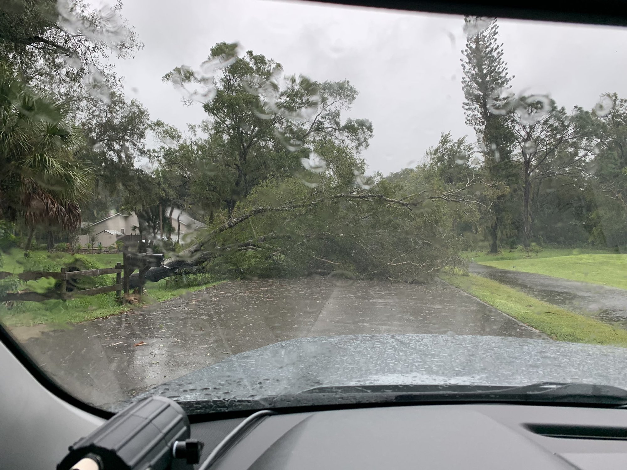
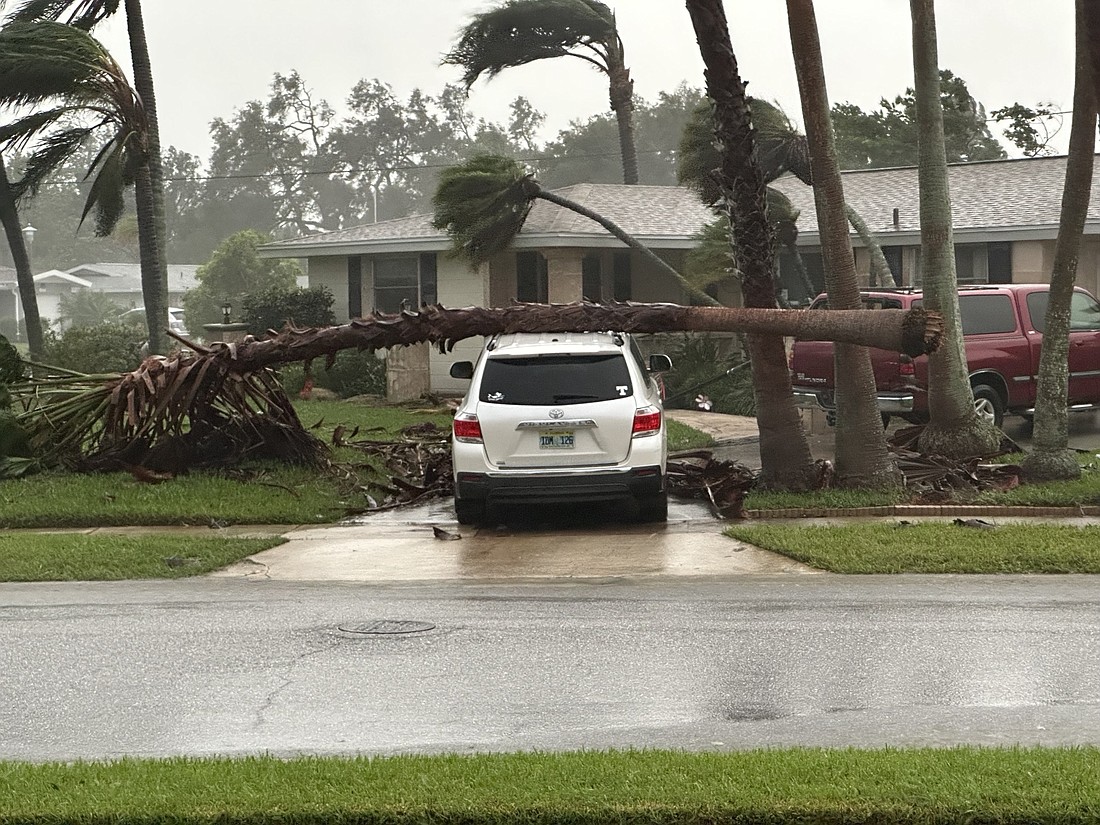
Winds of more than 100 mph and 10 inches of rain struck the east Manatee community of Myakka City, the worst weather the county experienced as part of the passage of Hurricane Ian, County Commission Chair Kevin Van Ostenbridge said in an Thursday afternoon update.
After initial assessments, two homes have been declared destroyed in Manatee County, 20 moderately damaged and 40 received some damage, though those figures will likely rise. Three families stranded in Myakka City were rescued, said Steve Litschauer, the county’s deputy director of emergency management. Those families were taken to temporary housing, and along with the Red Cross and other business partners, their needs are being addressed, he said.
“What we have seen, the west side was least hit, and the east side was more wind and flooding,’’ Litschauer said.
Damage assessment teams are relaying data on the conditions of neighborhoods by the hour. For instance, Litschauer said, cell service is spotty in the eastern sections of the county, and data from teams there will likely have to be downloaded upon their returns to base.
Van Ostenbridge said the focus on restoring power and other services is now on schools, hospitals, traffic signals and temporary housing sites. “We love you all, and we’re going to get to you, but we ask that you be patient,’’ he said. “If your power is out now, you might be out of power for a few days.’’
Van Ostenbridge said some of the 15 teams in the field checking on damage have reported that drivers are not stopping when approaching an intersection with inoperative traffic signals. He reminded drivers that such intersections are to be treated as a four-way stop.
He also reminded residents that trash service is expected to resume Monday and said that storm-debris piles should be placed separately from other trash, as a third-party collection service will be responsible for that waste.
“Some of us fared better than others,’’ Van Ostenbridge said.
Residents and business owners on Longboat Key were alerted around 1:30 p.m. Thursday that they could begin reentering the island, but with water and sewer service still shut down and spotty power service, the town said it hoped the visits would be brief.
Individuals coming to the island to assess their property are asked to do so and then exit the island again to not over-stress the utility system and create additional problems.
“We are happy to welcome you home, but we need your cooperation to restore services and utilities on the island,” the update said.
The city of Sarasota announced at 1:10 p.m. that Ringling Bridge is fully open. Water and sewer services have been restored in the city, but the barrier islands will be under a boil water notice through 1 p.m. Saturday.
Sarasota County officials said at 12:45 p.m. that utilities teams are working on Siesta Key to restore services. Access to the Key will remain closed while teams work. The county also stated that some evacuation centers received damage and have lost power, so those in centers could be moved to a different evacuation center.
The initial shift of first responders sent Thursday morning to assess damage on Longboat Key and clear roads for further island returns was packing up and heading home near Sarasota High on Thursday morning.
A second team was heading back out to continue the work.
Once the island is deemed safe, the town said the re-entry process will begin. AlertLongboayKey messaging will be used to notify residents.
The town reminded residents to be ready to present identification if asked before entering the town and visit longboatkey.org for the latest information.
Sarasota County water service will remain turned off to the barrier islands while utilities department personnel work to locate and repair damage to the system on the mainland, Public Utilities Director Mike Mylett said in a briefing Thursday morning.
“We're having challenges with unknown breaks,” Mylett said. “We can't find them at this point in time, so we're having a challenge maintaining pressure throughout the system.”
Service will not be restored to the barrier islands until all systems on the mainland are repaired. For now, because the system has not lost pressure, the water is safe to drink and use. Mylett urged residents who do have water to use it sparingly to help maintain pressure. Wastewater is also impacted by power outages, which shut down neighborhood lift stations.
Water customers within the county can can call 311 with any questions. Those outside the county can call 941-861-5000.
The Peace River Electric Cooperative, which serves homes in the eastern Bradenton and Lakewood Ranch areas, issued a press release Thursday morning saying it suffered extensive damage from Hurricane Ian Wednesday, leaving 88% of its consumers without power due to fallen wires, damaged poles and flooding.
“Much of what took us 82 years to build took Ian less than 24 hours to destroy,” said Van Crawford, PRECO vice president of operations, in a release. “With catastrophic winds and significant flooding, The recovery and rebuilding effort will be a lengthy and complicated process. PRECO is currently conducting damage assessments, a key first step to developing a roadmap to get the lights back on as quickly as possible. I thank our consumer-members for their notes of support and ask for their continued prayers and patience in the coming days.”
The release said more than 500 out-of-state line workers and contractors will join PRECO’s power restoration effort. Additional workers will be called in if necessary.
The hurricane has passed, but Sarasota County officials are asking residents to stay where they are while damage assessments on emergency routes and infrastructure are underway. During a Thursday morning briefing, Sarasota County Communications Director Jamie Carson reported Hurricane Ian inflicted most damage to south county communities, and for now first responders are only answering calls north of Highway 681.
Residents are being asked to not take storm debris to the curb at this time as crews work to clear roadways and emergency routes. Water remains turned off to the keys, and as it is restored boil notices will be issued.
In the meantime, Carson asked people to stay off roadways
“We know about hurricane season. We prepare year-round for this. This is what our team does. We ask that you follow our notices, you take heed to our warnings and you work together,” Carson said. "Take this time not to worry about the debris. Worry about your friends and family. Spend this time with your friends and family. Go check on that neighbor that you're worried about, and call 311. We'll provide you with updates as services become available.”
Power outages, which peaked at about 280,000, are now down below 200,000, Carson said. Cell reception remains interrupted in some areas.
A mapping team is working to create maps to indicate when it is safe for residents to leave their homes. It will include three color zones. Those in the red zone are advised to stay in place, those in the yellow zone are advised that only authorized personnel in vehicles will be out, and those in the green zone are free to move about. The map will be available on the county’s website at scgov.net.
In the meantime, Carson said residents should remain in place.
“I'm getting reports from our partners at the school district that we have people exiting the evacuation centers in north county,” Carson said. “We’re advising you that if you are exiting those evacuation centers, you are literally taking your life into your own hands because there are power lines down, there are branches and trees down in the roadways. There is standing water and we ask that you stay where you are.”
Manatee County announced a Thursday morning that evacuation orders have been lifted, and evacuation shelters are closing.
“This is not an all-clear,” Manatee County Administrator Scott Hopes said in the release. “There are still hazards out there. And you need to understand the danger.”
Hopes states that coastal Manatee received minor to moderate damage while the eastern portion of the county including Myakka City received a bigger impact.
Sarasota Police officers are at the Siesta Key bridge and the Ringling Causeway in the City of Sarasota because bridges remain closed. We know residents and business owners want to return. The water has not been turned back on and that process is underway. We’ll keep you posted.
Manatee County recovery efforts are underway.
Fuel is being delivered to shelters at Braden River High School, Lee Middle School and Bayshore Elementary School to fuel generators.
Utilities crews are working to restore wastewater service. More than 200 lift stations, which is more than 28% of the system, were offline across the county due to power outages. Generators will be deployed to get the impacted lift stations operational.
First In Teams will begin Thursday morning to help clear State Road 70 for Florida Power & Light crews. As of 5 a.m., 125,450 homes are out of power.
First In Teams also will make their way onto Anna Maria Island so utilities crews can restore the island's sewer service followed by its potable water.
Longboat Key Technical First In Teams have begun assessing the island, according to an Instagram post.
Once the Key is deemed safe, the reentry process will begin. Alert Longboat Key service will be used to notify residents once the reentry process begins. The post directed residents to the town's website for updates as they happen.
Sarasota and Manatee counties remain under hurricane storm surge warnings as rainfall and winds continue.
Teams in North Port have begun going out to clear critical roadways and assess damage. Tactical in-first teams in the rest of the county are expected to deploy through the night as sustained winds fall below 45 mph.
The USF Sarasota County Water Atlas shows that rainfall over the past 24 hours vary in the area from 4.13 inches near Rothenbach Park to 12.4 inches near Bahia Vista Street and McIntosh Road. The area between Venice and Englewood has received the most rainfall over the past 24 hours, from 14.13-17.2 inches.
Weather Bug shows Bradenton and Lakewood Ranch received 6.57 inches of rainfall Wednesday.
Read more: FPL states 90% of Sarasota and 68% of Manatee customers are without power.
Sarasota and Manatee county schools will remain closed through Friday.
The School District of Manatee County will decide when to resume classes once the storm has fully passed the area.
Once the storm has passed, all schools will be assessed for possible damage or needed maintenance, and the 17 schools that have been serving as shelters will be thoroughly cleaned and prepared to classes to resume.
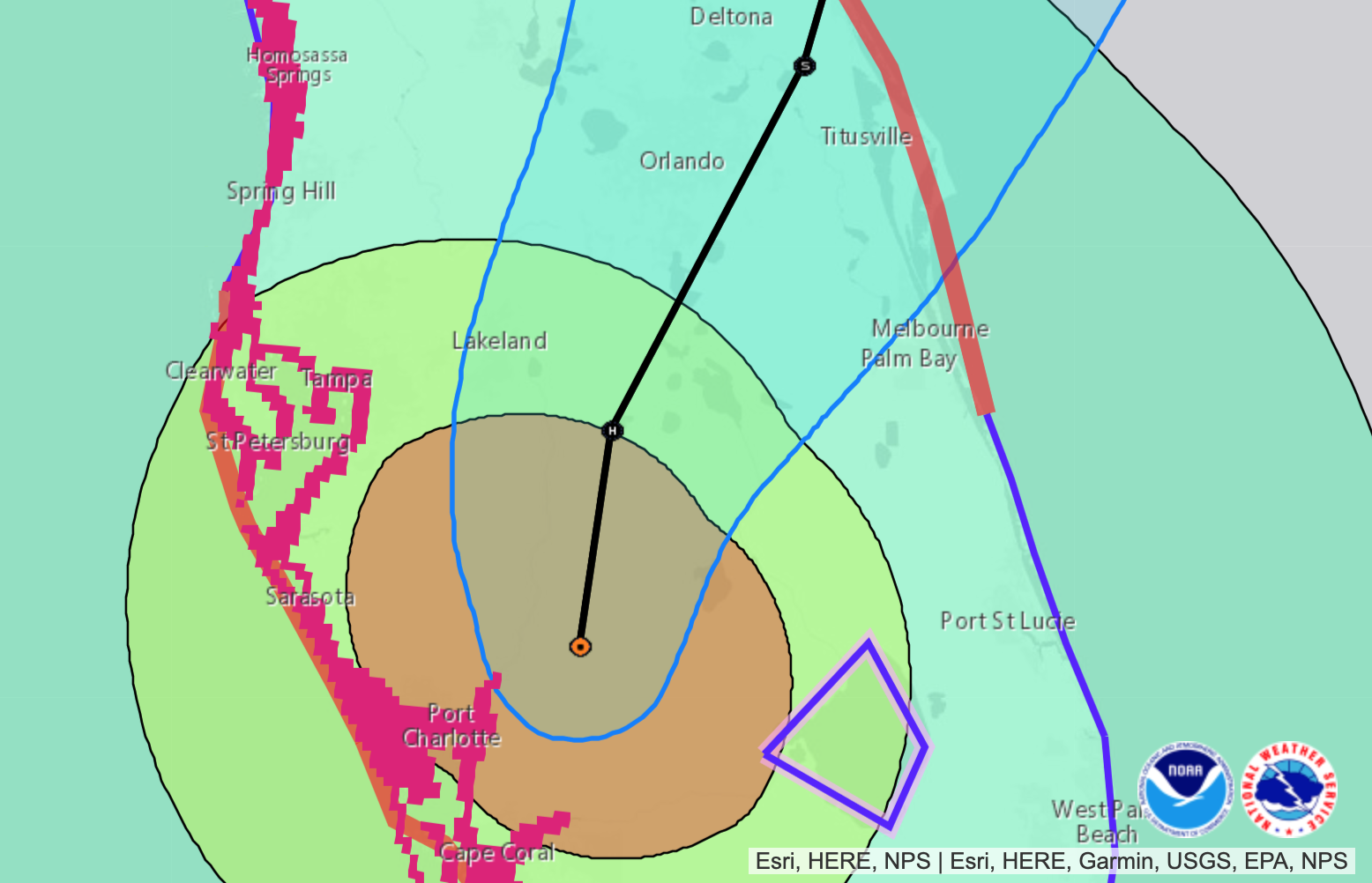
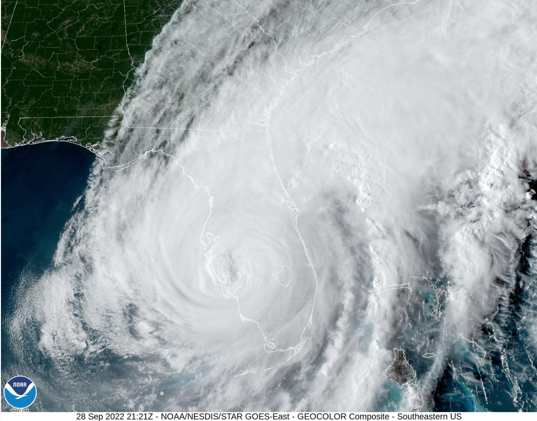
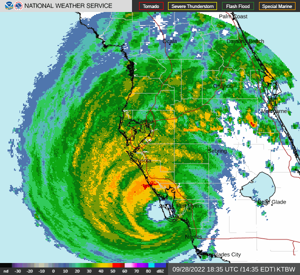
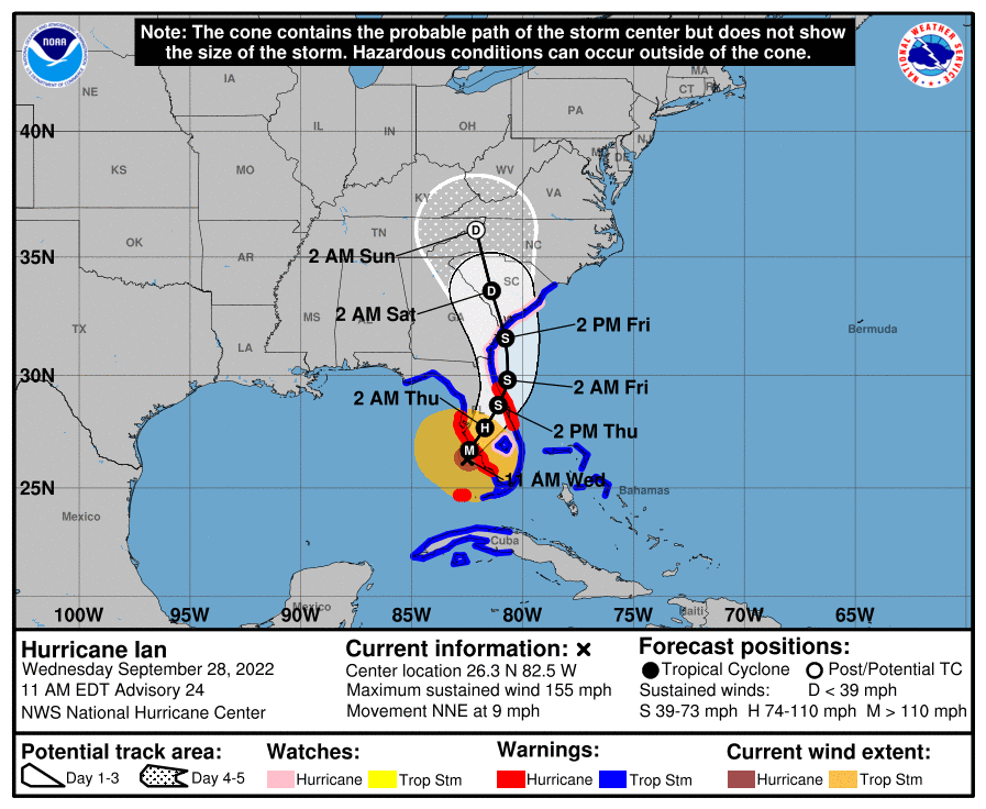
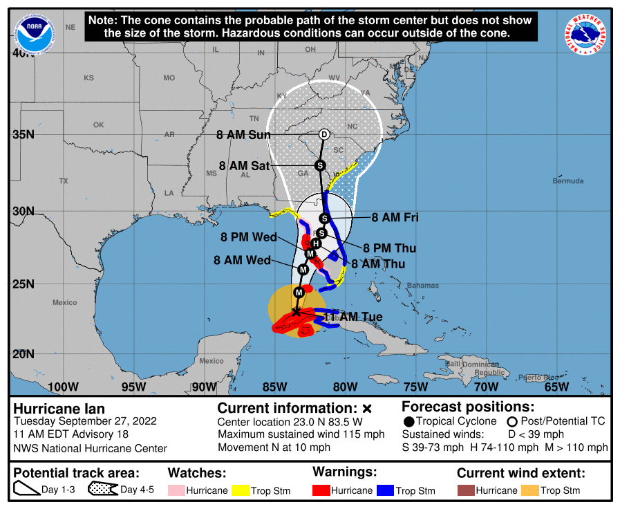
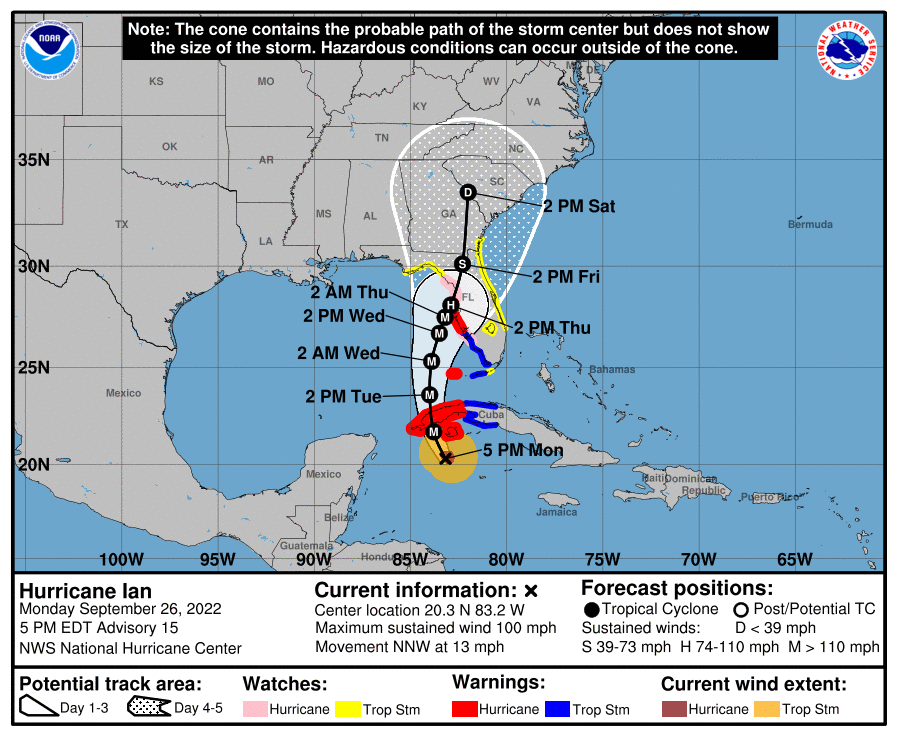
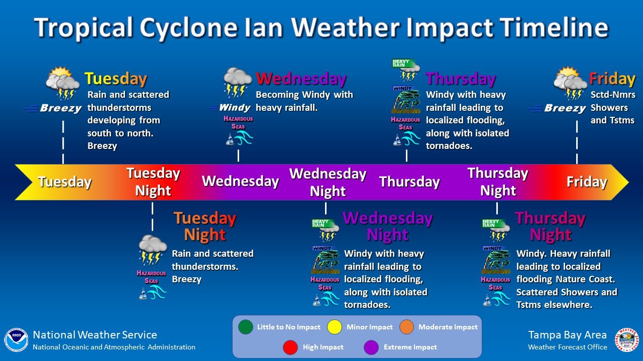
Hurricane Ian continues to move across the Florida peninsula with storm surge, winds and flooding, the National Hurricane Center says. Sustained winds are at 115 mph, a Category 3 hurricane.
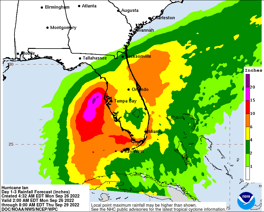
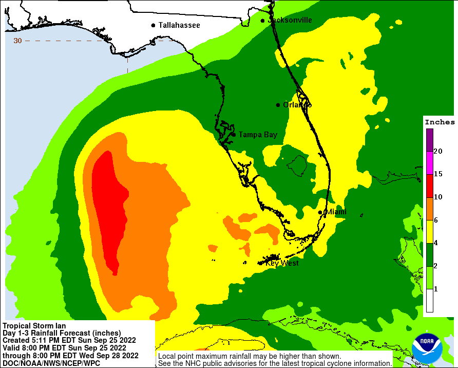
Central Florida could receive 12-20 inches, with local maxima up to 30 inches. Life-threatening flash and urban flooding is expected in the region through the week.
Forward movement has slowed to 8 mph. Ian is forecast to pass near Orlando by late morning or early afternoon Thursday.
Sarasota County teams hope to head out before dawn Thursday to begin assessing damage in the around Sarasota County, depending on National Weather Service outlooks on Hurricane Ian’s exit from the area.
First responders pulled back from nearly all emergency responses on Wednesday afternoon as Ian's sustained winds began exceeding 45 mph, first in the southern end of the county and then across its entirety.
Read more: About 86% of Sarasota County is without power
Emergency Management Chief Ed McCrane urged residents to stay off the roads until an all-clear is announced to avoid unnecessary hazards and to give assessment teams easier access to sites they need to examine, such as bridges, key roads and intersections, traffic signals and the state of traffic signs, debris, public areas and more.
Even with a start as early as 3 a.m. Thursday, McCrane said, it might take days for a countywide shift to all-clear status.
At 7:15 p.m., North Port was being hit the hardest by Hurricane Ian in Sarasota County.
General evacuation centers in Sarasota County are without power, director of communications for the county Jamie Carson said.
About 4,600 individuals and 560 pets are sheltering from Hurricane Ian in the evacuation centers.
Read more: About 75% of Sarasota County is without power
Medically dependent evacuation centers are operating on generator power and emergency operations personnel from the Emergency Operations Center are in communication with those centers via radios.
Carson reported a very high call volume with questions on a variety of topics to the 311 Contact Center. Emergency calls made include a structure fire earlier Wednesday, many alarm calls, roofs blown off and individuals stuck on the road driving toward another location.
"Right now, it's really important for our community to understand that we have tactical teams ready and they are poised to go out to our community and respond and to start to assess the damage," she said. "That can not happen until wind speeds go below 45 mph."
The county reported no plans for instating a curfew, and minimal vehicles have been seen out on the roads.
"For our community members, we want you right now to stay where you are," Carson said. "Ride out the storm. Wait for your local officials to let you know that it is safe to return."
She emphasized the need for community members to check on one another and hopes to begin freeing up the 911 Call Center. Community calls should be directed to the 311 Call Center as team members are on standby 24/7 to answer calls.
Hurricane Ian is located 5 miles east of Punta Gorda as sustained winds continue decreasing, at 140 mph as of the National Hurricane Center's 5 p.m. update. Ian is expected to move across Central Florida and emerge into the western Atlantic Ocean by late Thursday.
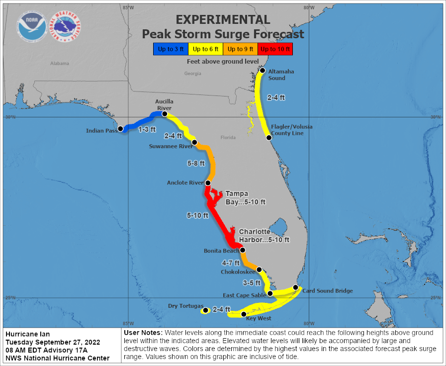
Sarasota and Manatee County expect 4-6 feet of storm surge north of mid-Longboat Key and 6-10 feet south of mid-Longboat Key.
Ian moves through Central Florida as a Category 4 hurricane with 145 mph sustained winds.
Sarasota and Manatee counties remain under hurricane and storm surge warnings as well as flood watch.
The center of Hurricane Ian has made landfall near Sanibel and Captiva islands with 155 mph sustained winds.
Ian is forecast to move over Central Florida through Thursday morning.
Although the worst of Hurricane Ian has yet to hit Manatee County, Administrator Scott Hopes said water, sewage and power line problems already are being realized.
Manatee County reported that two of three water line breaks already have been repaired, and that 15% of its lift stations (which transfer sewage) are down. Hopes said residents need to flush "judiciously."
Manatee County spokesman Bill Logan said the 15 lift stations that aren't operating are located all around the county. He said the stations are powered by electricity and the problem is a mechanism, operated by electric, that moves wastewater to treatment facilities. The lift stations have emergency generators, but the county can't get the personnel to them during the storm to start them.
Logan said all county residents are asked to limit flushing, showering and laundry.
Hopes said if water coming out of the tap doesn't smell right or look right, "don't drink it."
As of 2:30 p.m., approximately 36,450 homes were without power in Manatee County. Hopes said there already are significant downed power lines.
Read more: FPL customers in Sarasota, Manatee counties face power outages
"We also have several traffic signals dangling," Hopes said. "You are going to wake up tomorrow to a different landscape."
At a press conference, Hopes also reminded residents not to run a generator in the garage with the garage door open because it won't effectively remove dangerous gases.
Hopes said residents should shelter in place until public officials make an announcement that it is safe to do so.
"Don't be a disaster tourist," Hopes said. "Allow us the freedom on the roads to get the work done."
All Manatee County employees have been asked to be available for recovery work. Hopes said recovery work should begin approximately 11 a.m. on Thursday. He said winds are expected to subside at 10 a.m.
"There will be downed power lines, sharp debris. … It is not going to be safe to go out immediately," Hopes said.
Hopes reminded residents that once it is clear to return to the streets that they should "turn around" if they come to any standing water on the road.
The National Hurricane Center states Hurricane Ian is causing catastrophic storm surge, winds and flooding across the Florida peninsula.
Ian remains with maximum sustained winds of 155 mph and forward movement at 9 mph. The hurricane is located 25 miles west-northwest of Fort Myers. The center is expected to move onshore soon, NHC says, before moving over Central Florida through Wednesday night.
Sarasota County emergency managers gave the order for all emergency vehicles to stop responding as winds countywide have risen above 45 mph. Those calling for 911 assistance will receive guidance on sheltering in place.
"That's how serious this is,'' said Emergency Management Director Ed McCrane, adding those with questions can call the county's 311Connect line.
State Road 681 near Laurel will be the next milestone for the suspension of emergency services as winds of 45 mph or more move from south to north along the length of Sarasota County, Director of Communications Jamie Carson said.
Carson said the fluid situation will likely continue throughout the afternoon as Hurricane Ian moves ashore. She said those who call 911 for emergency help south of those 45 mph milestones will likely be offered guidance and advice on sheltering in place until conditions improve. First responders, too, are sheltering in place while conditions become too hazardous.
The highest gust yet recorded at Sarasota-Bradenton International Airport was 67 mph. In Venice, the highest gust was 75 mph and sustained winds have been above 46 mph since noon.
"Put as many walls between yourself and the outside,'' she said, in advising residents on how to be as safe as possible at home, moving to an interior space such as a closet or a bathroom.
Saying the conditions have reached a life-or-death stage, "Hurricane Ian is nothing to laugh about.''
About 5,000 people have checked into one of the county's 14 shelters, some of which have been locked down in the face of worsening weather conditions. When asked what would happen if evacuees showed up at an already locked-down facility, Carson said every effort would be made to help those people, but the overall safety of the shelter would also have to be taken into consideration.
Worsening weather is likely to continue throughout the afternoon and into tonight, she said.
Carson also said the call volume to the county's 311Connect service is rising as the conditions deteriorate.
"It's about human connection" as much as helping callers, she said, also urging residents to pause and call family or friends from time to time while power or cell-network service remains operational.
Waffle House announced it has closed 21 locations from Bradenton south to Naples, including the two in Bradenton and two in Sarasota County, as Hurricane Ian pushes into the state Wednesday morning.
Njeri Boss, the company’s vice president of public relations, says more closings could be on the way. The chain will make the call on what to do with other locations as the storm progresses.
“Safe operation remains paramount to decisions we make,” he says.
Although there’s long been a joke about people not worrying about a storm until the local Waffle House closes, the restaurant chain is an acknowledged authority on weather events with professionals tracking the unofficial Waffle House Index during storms.
The index, a term invented by former FEMA administrator Craig Fugate according to AccuWeather, is “an informal measure of a storm’s severity and its effect on a stricken community.”
“Waffle House, especially the locations in areas that get a lot of hurricanes, has a reputation for its effective handling of disasters,” AccuWeather says. “It has a limited menu prepared for times of food shortages and power outages. It also assembles ‘Waffle House jump teams’ who can quickly reopen the restaurant after a disaster as soon as it is safe to do so.”
Sustained winds of 45 mph have hit Sarasota County, officials report. The county urges residents to shelter in place as Hurricane Ian passes. Emergency services have shut down from Center Road south. Services north of Center Road will begin shutting down as winds move north.
Wind speeds at Sarasota-Bradenton International Airport have been steadily climbing since midnight in association with Hurricane Ian. A few minutes before noon Wednesday, the airport reported the highest gust yet, 60 mph, with sustained winds of 33 mph. From around 6 a.m., the highest gusts have risen from 38 mph to 52, 54, 58 and then 60 mph, veering from an easterly direction to the present northeasterly direction.
If you're located in Sarasota County, you can call 311 for assistance. Call 941-861-5000 if you are outside of the county.
11:50 a.m.: Longboat provides update and steps following storm
Hurricane Ian, at a near-Category 5 with 155 mph sustained winds, is located 45 miles west-northwest of Naples, the National Hurricane Center says. The eyewall has begun moving onshore.
Forward motion has slowed to 9 mph.
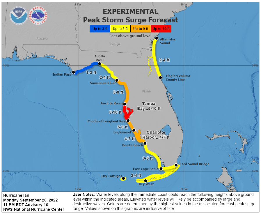
Water could reach 4-6 feet above ground from Anclote River to mid-Longboat Key and 6-10 feet from mid-Longboat Key to Englewood. Englewood to Bonita Beach could see a 12- to 18-foot storm surge.
Tornadoes are possible in the region through Wednesday night.
Meanwhile, Manatee County Administrator Scott Hopes announced via social media channels that the county is locking down. That means shelters are closing their doors, transit is shutting down and law enforcement personnel are evacuating the barrier islands for safer locales.
“People will be kept off the roads because it’s no longer safe to travel,” Hopes said. “We ordered over 120,000 evacuations yesterday and only have about 3,000 people in our shelters, so hopefully you evacuated to a friend’s house or another safe location because we are about to feel the brunt of a near Category 5 hurricane.”
The county’s “first in” teams are staged in seven locations throughout the county awaiting deployment as soon Ian passes. The teams are equipped with vehicles and equipments necessary to clear roads as soon as possible.
“As the storm passes and the weather begins to improve, it does not mean it's safe to exit your homes,” Hopes said. “There will be downed power lines. We are expecting exceptional rainfall, as much as 13 inches over the next 24 hours, that will flood our creeks, our storm drains as well as many of your neighborhoods.”
Hopes also cautioned the expected storm surge will not occur as Ian comes ashore, but rather on the back end of the storm as the winds shift direction toward the coastline.
"Stay inside, and please please heed warnings,” Hopes said. “You will get mobile phone alerts. We will inform you after the storm passes when it is safe to go outside.”
The video announcement can be viewed here.
10:15 a.m. Wednesday, Sept. 28
In a press conference, Sarasota County officials noted that the arrival of 45 mph winds from Hurricane Ian is imminent and this is the last opportunity for residents who are in evacuation levels A or B to leave safely.
Once the threshold of 45 mph winds is reached, the county will pull all emergency vehicles from roads and they will no longer be able to respond to calls.
The county is planning to send out a push notification alert once winds reach 45 mph to let residents know it is too late to evacuate and residents will need to shelter in place until the storm passes.
The storm surge is forecasted to be up to 18 feet in some areas. Jamie Carson, director of communications for Sarasota County, said even though people may not be on the coast, they still need to be aware of the effects surge can cause in waterways around them. “Just because you don’t see water and just because you don’t have an ocean view … that doesn’t mean you won’t be impacted by rising waters,” she said.
Carson said this is the time for neighbors to reach out to those around them who might need help. “If you have a neighbor who might have some additional needs, check on them, make sure they’re OK,” she said. “We’re a community, and we need to get through this together.”
The county is working with state agencies and the National Weather service to monitor the storm and Florida Power & Light on the latest power outages. Once emergency response is pulled at 45 mph, the county will wait until the storm passes to fully assess damage and begin emergency response and recovery efforts.
Sustained winds remain at 155 mph, near a Category 5 hurricane. Ian is located about 60 miles from Naples, with hurricane-force winds reaching Sanibel Island, the National Hurricane Center states. The Southwest Florida International Airport recently recorded winds of 62 mph.
9:30 a.m.: Manatee officials ask residents to shelter in place as Hurricane Ian arrives
Sarasota County reminds residents to keep generator safety in mind. Do not run a generator in your home or garage. Place it at least 20 feet from the home — not close to living quarters, doors, windows or vents — with the exhaust facing away from the home.
Ian approaches a Category 5 hurricane with 8 a.m. sustained winds of 155 mph, located about 55 miles west of Naples.
The National Hurricane Center expects Hurricane Ian to make landfall Wednesday morning or early afternoon.
Rainfall in Central Florida will be 12-18 inches, with isolated totals up to 24 inches. Water could reach 4-6 feet above ground from Anclote River to mid-Longboat Key and 6-10 feet from mid-Longboat Key to Englewood.
Live footage: View a live video of Siesta Key Beach at SiestaKeyHOS.com/web-cam. Live video of traffic intersections across the area are available at SmartTrafficInfo.org.
Sustained winds at the Sarasota-Bradenton International airport are at 39 mph. When local winds hit 45 mph, Sarasota County urges residents to stay where they are.
Tornadoes are likely in the region through Wednesday night.
Shelter update: In an 8 a.m. Wednesday update, there are 2,600 people and 300 pets in Sarasota County shelters. Capacity is 26,000, and all shelters are open to pets.
Sustained winds in the area are expected to surpass 45 mph in the area in by late morning. The county emphasizes that residents should stay where they are once winds hit 45 mph; county emergency services will also shut down at that time.
Although travel is discouraged, the Florida Highway Patrol this morning closed the Sunshine Skyway bridge linking Manatee and Pinellas counties, prompted by winds of 50-60 mph. The FHP said the bridge would not reopen until storm conditions passed.
Ian continues as a Category 3 hurricane with sustained winds of 120 mph. At the National Hurricane Center's 11 p.m. update, Ian was 110 miles southwest of Naples.
The Sarasota-Manatee region remains in a hurricane warning and a storm surge warning as Ian approaches the Florida peninsula. Hurricane-force winds are expected in the region beginning Wednesday morning.
The hurricane's center is forecast to move over Port Charlotte on Wednesday night into Thursday morning, making landfall as Category 4.
The United States Postal Service on Tuesday night announced a suspension of mail service and retail operations until further notice for a wide swath of Central Florida and Southwest Florida, including all of Manatee and Sarasota counties.
Postal operations are suspended roughly from Hernando County, about 80 miles north of Tampa south to Naples, and as far inland as Lakeland and Immokalee.
The statement from the Postal Service said the suspension was for the safety of its delivery personnel and other staffers and did not offer a date for service resumption.
7:30 p.m.: Sarasota County urges Zone A, B residents to evacuate
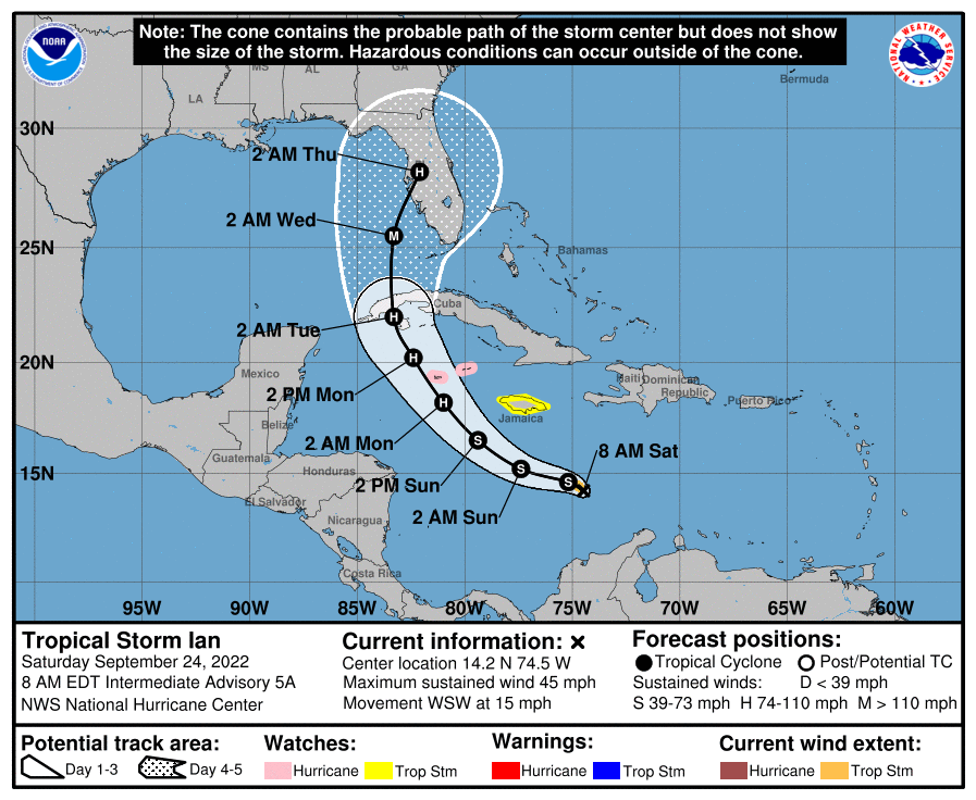
Hurricane Ian is about 230 miles south of Sarasota, the National Hurricane Center states in its 5 p.m. update. It continues moving at 10 mph with Category 3 sustained winds of 120 mph. Ian is forecast to turn toward the east and slow forward movement from Tuesday night through Wednesday and make landfall near Englewood on Wednesday afternoon and night as a Category 4 hurricane.
The Florida region under a hurricane warning is from Chokoloskee north to the Anclote River. A storm surge warning covers the entire west coast of the Florida peninsula.
Water could reach 4-6 feet above ground from Anclote River to mid-Longboat Key and 8-12 feet from mid-Longboat Key to Bonita Beach.
Ian is moving north through the Gulf of Mexico as a Category 3 hurricane, with sustained winds at 120 mph. The National Hurricane Center expects Ian to start turning toward the east and slow forward speed Tuesday night; as of 2 p.m. it moving at 10 mph. The track still expects a landfall near or in Venice as a Category 3 hurricane. Storm surge and hurricane warnings remain.
Disaster preparedness information by local government:
Sarasota County officials have expanded evacuations to now include Zone B, which is the second-most vulnerable areas of the county. The county on Tuesday ordered evacuations of those living in mobile homes, RVs and boats, along with those living in the most vulnerable areas of the county. In total, about 151,000 people have been ordered to evacuate, county officials said. Since Hurricane Irma in 2017, the county no longer classifies evacuations as mandatory or voluntary. To check your evacuation zone, visit ags3.scgov.net/knowyourlevel.
Hurricane Ian shifts east again, currently pointed toward Venice. Sustained winds are 115 mph, still a Category 3 hurricane, as Ian moves into the Gulf of Mexico. Restrengthening is forecast by the National Hurricane Center through Wednesday.
Rainfall will be 12-16 inches, with isolated totals up to 24 inches. Water could reach 5-8 feet above ground from Anclote River to mid-Longboat Key and 8-12 feet from mid-Longboat Key to Bonita Beach. Storm surge and hurricane warnings in the region continue.
Tornadoes are possible from Central Florida to the Florida Keys through Wednesday.
10:26 a.m.: Manatee County orders more mandatory evacuations in face of Hurricane Ian
Hurricane Ian hit became a Category 3 hurricane overnight, now with 125 mph sustained winds as it moves over Cuba, the National Hurricane Center states.
Ian is forecast to upgrade to a Category 4 by Tuesday afternoon, and the center is currently expected to hit the Sarasota-Manatee area late Wednesday as a dangerous major hurricane.
Tropical storm conditions are expected in the region later Tuesday. Rainfall will be 12-16 inches, with isolated totals up to 24 inches. Sarasota-Manatee could receive water reaching up to 5-10 feet above ground. Considerable flooding is expected mid- to late week.
The Anclote River south to Bonita Beach is under hurricane warning. The Anclote River south to Flamingo is under storm surge forecast.
As of the National Hurricane Center's 11 p.m. forecast, Hurricane Ian has increased to maximum sustained winds of 105 mph. Advisories for Sarasota-Manatee have not changed. Hurricane-force winds are expected beginning Wednesday morning. Prolonged river flooding is likely.
The NHC aims the hurricane path at Treasure Island. The last major hurricane to impact the Tampa Bay area was in 1921.
The National Hurricane Center forecast for Hurricane Ian is steady from 5 p.m. Maximum sustained winds stay at 100 mph as Ian approaches Cuba as a Category 2 hurricane. Ian is expected to become a Category 3 by early Tuesday.
Sarasota-Manatee remains under a hurricane warning and a storm surge warning. Tropical-storm-force winds are most likely to hit the area Tuesday night, according to the National Hurricane Center.
The Sarasota-Manatee region is under a hurricane warning and a storm surge warning as Hurricane Ian quickly intensifies, the National Hurricane Center states in its 5 p.m. update.
Maximum sustained winds have increased to 100 mph, making Ian a Category 2 hurricane. Winds are forecast to increase to 130 mph, a Category 4 hurricane, as Ian approaches the region.
Mid-Longboat Key and north could receive water reaching up to 5-10 feet above ground; south of mid-Longboat could reach 5-8 feet.
Tropical storm conditions are expected in the area Tuesday evening, with hurricane conditions Wednesday. Rainfall through Thursday in central west Florida is forecast at 6-12 inches, with local maxima up to 20 inches. Flash and urban flooding impacts are possible through mid-week.
Read more: Manatee County officials say they are ready for Hurricane Ian
Hurricane Ian's sustained winds have increased to 85 mph in National Hurricane Center's latest update. The Sarasota-Manatee area is under a storm surge watch and a hurricane watch.
The center of Ian is forecast to pass near or over western Cuba on Monday night through early Tuesday and then pass west of the Florida Keys late Tuesday.
Rapid strengthening of Ian continues to be expected over the next day, and NHC forecasts it will become a major hurricane by early Tuesday.
Tornadoes are possible through Tuesday in Central Florida south to the Keys.
1:10 p.m.: Sarasota County orders evacuation of most-vulnerable zone
12:14 p.m.: County could cut Longboat water supply before storm, chief says
11:59 a.m.: Sarasota closes schools, sets emergency state
11:40 a.m.: Manatee County issues evacuation orders
Hurricane Ian continues to rapidly strengthen, with sustained winds increasing to 80 mph. It will be upgraded to a Category 2 when sustained winds hit 96 mph.
Sarasota County has declared a local state of emergency. Manatee County declared a local state of emergency Friday.
Ian is forecast to become a Category 3 hurricane by Tuesday morning and Category 4 from late Tuesday to late Wednesday, according to the 11 a.m. National Hurricane Center update. It is expected approach the west coast of Florida late Wednesday into Thursday.
Sandbags: Sandbag distribution locations are open in Manatee, to open in Sarasota, Longboat
Water could reach 5-10 feet above ground from Anclote River to mid-Longboat Key if peak storm surge hits during high tide. Mid-Longboat to Englewood could see water 5-8 feet above ground. Tropical storm wind conditions are expected to begin in the region by Tuesday night, with hurricane winds likely Wednesday.
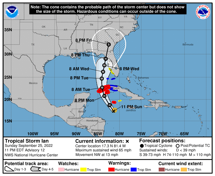
Tropical Storm Ian has upgraded to a Category 1 hurricane, with 75 mph maximum sustained winds, according to the National Hurricane Center's latest update.
Ian is forecast to rapidly strengthen throughout Monday. A hurricane watch has been issued in Sarasota and Manatee counties, in total from north of Englewood to the Anclote River. A storm surge watch has also been extended north to the Anclote River.
The path of Ian is forecast to pass west of the Florida Keys late Tuesday before turning slightly eastward and approaching Florida's west coast Wednesday as a Category 3 or 4 hurricane.
If peak surge occurs at high tide, water in Sarasota-Manatee could reach 5-8 feet above ground, according to NHC. Tropical storm winds are expected in the area beginning Tuesday evening. Central west Florida faces 8-10 inches of rainfall, with local maximum up to 15 inches. A few tornadoes are possible as well through Southern Florida and Central Florida.
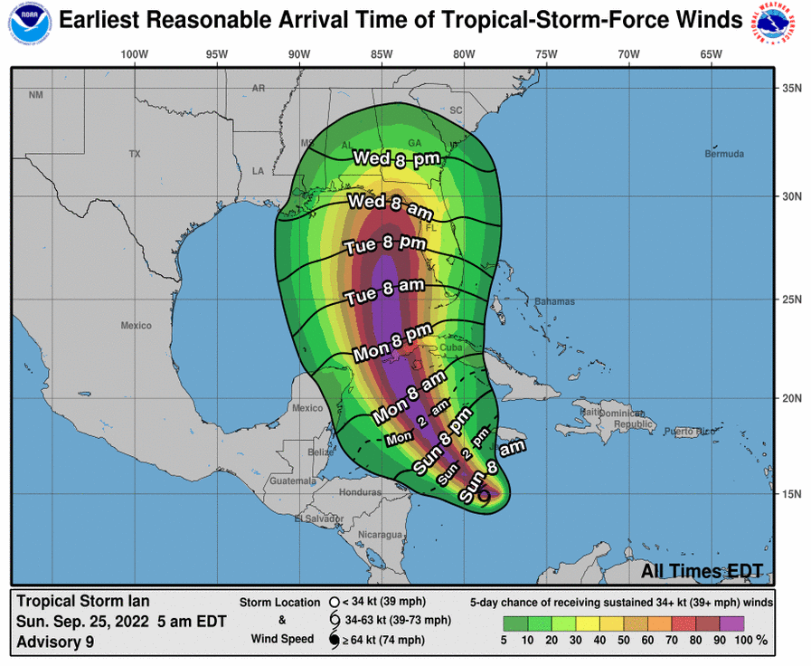
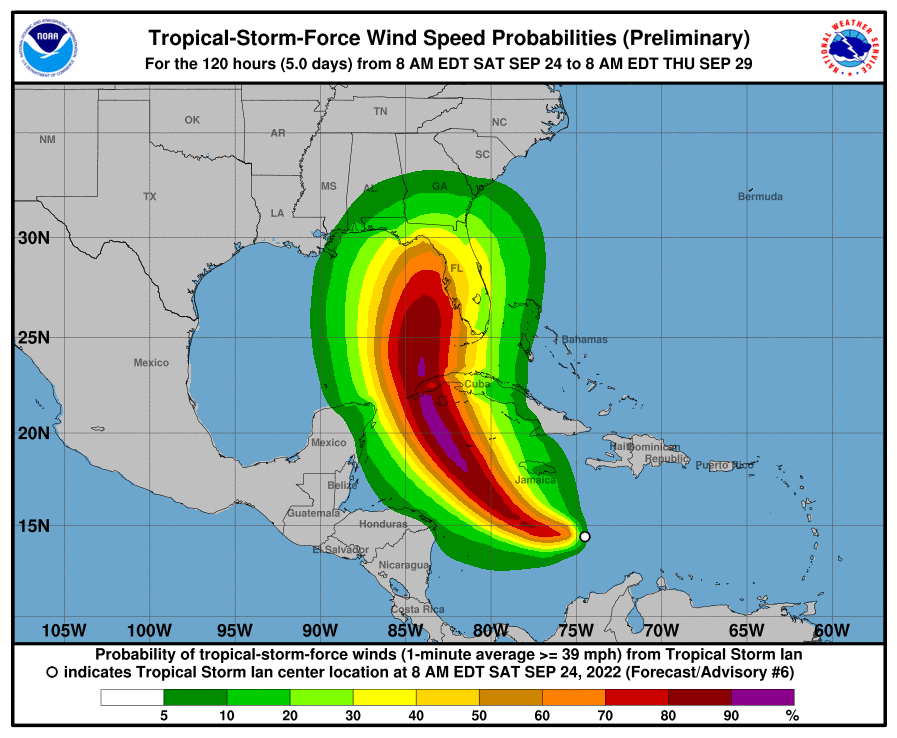
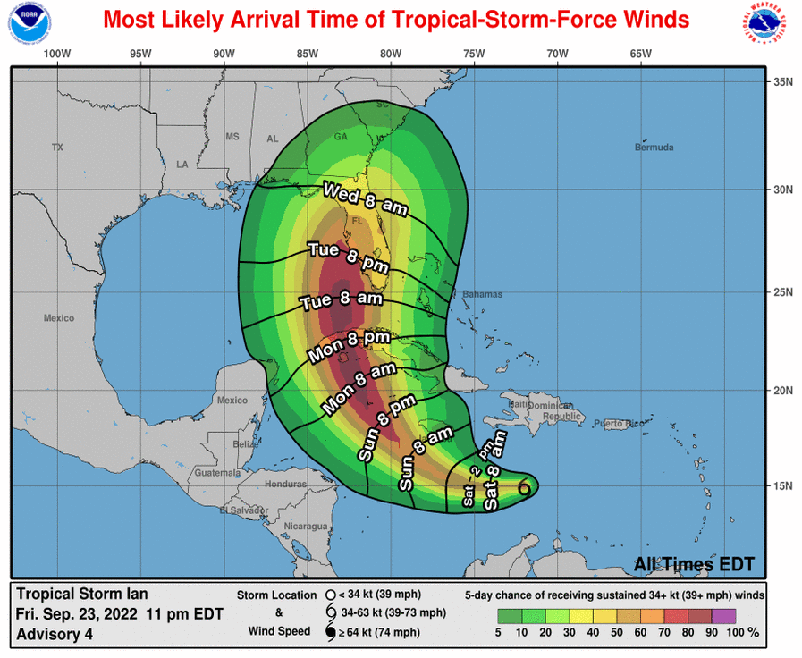
According to the National Weather Service, Sarasota County now has a 91% chance of experiencing at least tropical storm force winds of 39 mph or more, which could arrive as early as 8 a.m. Tuesday but most likely by 8 p.m. Tuesday.
The National Hurricane Center's 11 p.m. update states that Tropical Storm Ian continues to strengthen and will rapidly do so Monday and Tuesday. Maximum sustained winds are now at 65 mph.
Ian's forward speed is expected to slow Tuesday as it turns northward. The potential track has shifted slightly back eastward, showing Ian passing the Sarasota-Manatee area as a major hurricane Wednesday evening, though the National Hurricane Center states that uncertainty in the track and intensity forecast remains higher than usual.
A tropical storm watch has been issued for Florida's west coast from Englewood to Chokoloskee. Tropical storm conditions are possible by Tuesday evening in the region under the watch. Considerable flooding impacts are likely in the central west region of Florida.
The one- to three-day potential track area for Ian includes the Sarasota and Manatee region. Sarasota-Manatee is also forecast in a high five-day chance of sustained winds above 39 mph.
8:30 p.m.: Manatee County schools to remain open Monday
Tropical Storm Ian continues strengthening as it moves toward Cuba, according to the National Hurricane Center's latest update. Maximum sustained winds have increased to 60 mph. Ian will be named a hurricane when sustained winds hit 74 mph, which is forecast to occur Monday.
Heavy rains could affect the region Thursday through Saturday, causing flash and urban flooding.
Monday classes will proceed as scheduled for Sarasota County Schools, though decisions on a Sarasota County state of emergency will likely be made by school officials and county emergency managers in the next 24 hours.
The National Hurricane Center's 5 p.m. prediction moved the track of soon-to-be Hurricane Ian about 20 miles east of its previous track, perhaps indicating the westward trend of the forecasts had ended. The NHC showed a potential hurricane landing in the Big Bend region of Florida very early Thursday morning.
Craig Maniglia, the director of communications and community relations for Sarasota County Schools, confirmed classes are planned for Monday but that "there is a possibility that all public schools will close Tuesday, Sept. 27 for shelter openings.''
Sara Nealeigh, a spokeswoman for Sarasota County, said officials continue to monitor the storm, watching not only the forecast course and intensity.
In a briefing from the National Weather Service on Sunday, shared by the city of Sarasota, forecasters said there was a 40-70% chance of tropical storm force winds of 39 mph or higher reaching Sarasota County by 5 p.m. Tuesday and rainfall totals of 5-10 inches could be widespread in the next seven days.
Among the National Weather Service's key points:
The Weather Service said Ian's turn to the north, which is expected today, will likely determine how far west the storm ends up passing.
Maximum sustained winds are around 50 mph with higher gusts as Tropical Storm Ian moves toward Cuba, where The National Hurricane Center forecasts it will hit Tuesday as a Category 3 hurricane.
Ian is expected to strengthen to a Category 4 hurricane as it moves through the Gulf of Mexico toward the Florida Panhandle. The Florida Keys up to Central Florida is forecast to get 2-4 inches of rain, with local maxima of 6 inches from Monday through Wednesday morning. The National Hurricane Center states flooding is possible through the week, especially in Central Florida.
The hurricane track estimates Ian will make landfall on the Panhandle on Friday morning as a Category 1 hurricane. The entire Panhandle through Fort Myers remain in the cone of uncertainty.
The National Hurricane Center forecast shifts Tropical Storm Ian's path slightly west toward the Florida Panhandle. Tropical-storm-force winds are projected to hit Sarasota-Manatee as early as Tuesday evening as Ian passes through the Gulf of Mexico.
Maximum sustained winds increase to 50 mph as Tropical Storm Ian continues intensifying, the National Hurricane Center states in its 11 p.m. update. Ian is expected to begin rapid strengthening Sunday and then pass near or over western Cuba as a major hurricane Monday night or early Tuesday.
The National Hurricane Center forecast track line has shifted Ian to approaching Northern Florida on Thursday night, with the cone of uncertainty covering the Panhandle to Central Florida, including Sarasota and Manatee counties.
Tropical Storm Ian is expected to rapidly strengthen over the next couple days as it moves west across the Caribbean Sea, according to the National Hurricane Center's latest update. It is forecast to turn northwest Sunday and Monday and toward the north Tuesday as it emerges over southeastern Gulf of Mexico.
3 p.m.: Manatee County declares local state of emergency for Tropical Storm Ian
Maximum sustained winds remain around 45 mph. Ian is forecast to become a hurricane by late Sunday and strengthen into a major hurricane late Monday or early Tuesday.
The Florida Keys and Southern Florida are expected to receive 2-4 inches of rain, with local maxima of 6 inches through Tuesday. The National Hurricane Center states flash and urban flooding is possible across the Florida Keys and peninsula through mid-next week.
The National Hurricane Center forecasts Tropical Storm Ian to rapidly strengthen later through the weekend in its 2 p.m. update. The storm continues to move west and is forecast to turn northwest Sunday.
Ian is expected to be at hurricane strength by Sunday night before approaching western Cuba late Monday.
Tropical Storm Ian's forecast path in the past 24 has shifted west, now in the most recent update of the National Hurricane Center's projections, making landfall north of Tampa Bay on Thursday morning as a Category 3 hurricane.
Be prepared: Experts advise early preparation, decisive action
Since Friday, the NHC's cone of uncertainty has shifted from enveloping all of Florida's peninsula to now leaving extreme southeastern sections outside of the zone, though now also including more of the panhandle's counties.
The 5 a.m. forecast from the National Hurricane Center predicts the center of an intensifying Tropical Storm Ian to be close to the coast of Sarasota and Manatee counties by around midday Wednesday.
The storm, which was upgraded overnight from a tropical depression, is forecast to become a hurricane in the Caribbean Sea by early Monday before passing near the Cayman Islands and over the western portion of Cuba by Tuesday morning.
By Wednesday morning, it's forecast to become a Category 3 hurricane with maximum sustained winds of 111 mph to 129 mph. Winds of 115 mph are predicted at landfall. All but Florida's westernmost panhandle counties are in the National Hurricane Center's prediction cone.
No warnings or watches are posted for Florida, though Gov. Ron DeSantis late Friday placed 24 counties in the southern tier of the peninsula in a state of emergency. Sarasota and Manatee counties are included in that list.
“Today, I signed an Executive Order issuing a State of Emergency due to the threat of Tropical Depression 9,” DeSantis said. “This storm has the potential to strengthen into a major hurricane and we encourage all Floridians to make their preparations. We are coordinating with all state and local government partners to track potential impacts of this storm.”
Both Sarasota County and Manatee County emergency managers posted statements Friday.
"As the path and intensity of the depression remain uncertain, all of Sarasota County is encouraged to review their emergency preparedness plans in the event the storm will have an impact on our community,'' Sarasota County Government Emergency Services said in a social media post.
The 11 p.m. forecast from the National Hurricane Center upgrades Tropical Depression 9 was to Tropical Storm Ian, with expectations it will hit Florida on Tuesday.


