- July 13, 2026

-
-
Loading
Loading
As the Urban Design Studio prepares to unveil a new zoning code for the city of Sarasota within a year, residents of the city’s barrier islands are getting their first glimpse of how the changes might affect their neighborhoods.
The Urban Design Studio, tasked with rewriting the city’s zoning regulations to be more predictable and incorporate new urbanist principles, is visiting with residents of the city to gather information for the new code. In March, its attention has been devoted to the city’s barrier islands, extending from Golden Gate Point to Lido Key.
For most of the month, that information gathering came in the form of small walking tours with residents of each individual area. The goal, according to Urban Design Studio Director Karin Murphy, is to get a sense of what residents like and don’t like about their neighborhood so the code can reflect those desires.
On Saturday, however, the Urban Design Studio invited all the neighborhoods throughout the area to a presentation at Mote Marine Aquarium — an opportunity for barrier island residents to see how the new code could function in conjunction with their surroundings.
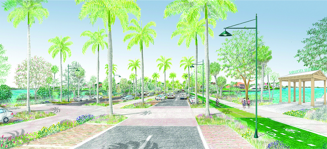
Although the neighborhoods each come with their own specific needs and wants, there are some elements uniting them that the Urban Design Studio plans to target in the new code. Perhaps most significant among those is the entryway to the barrier islands along the John Ringling Causeway and John Ringling Boulevard. At Saturday’s meeting, the Urban Design Studio showed attendees a concept plan that significantly reimagined the roadway from Bird Key to St. Armands Circle.
The reimagining was done with one substantial goal in mind: getting cars off of the roadway to reduce the burden on the congested corridor. Murphy highlighted a multifaceted approach to achieving that goal, with provisions for walkers, bikers and people using public transit included in the conceptual images.
Between St. Armands Circle and the Coon Key Bridge, the plans also imagined up to 200 additional parking spaces. Principal Urban Designer Andrew Georgiadis has explained that the potential parking along John Ringling Boulevard would serve several purposes: One, it would mirror the other spokes coming out of St. Armands Circle, along which parking extends. Two, it would slow traffic going into and coming out of the Circle, with drivers forced to adjust to the friction created by the parked cars.
Third, it would help alleviate some of the parking and congestion issues around St. Armands Circle without having to construct a parking garage.
“We’ve seen that, if it’s a good walk, people are willing to walk,” Murphy said. “The goal is to intercept cars before the Circle to reduce pedestrian conflicts.”
The vision also included a water taxi stand, wider sidewalks and separate bike lanes along John Ringling Boulevard. One particular area of concern for pedestrians and bikers is the Coon Key Bridge, especially its narrowness. Murphy said the bridge is at the end of its lifespan, and that when it is replaced, it could be widened to include amenities mirroring those imagined for the rest of the corridor.
“There’s no bike provision and a very small area for the pedestrians there,” Murphy said. “We looked at ways in which, with a new bridge, that could be expanded to allow for that bike provision, to have a much larger sidewalk.”
The scope of the Urban Design Studio’s work is much wider than just the St. Armands corridor — in particular, it’s interested in preserving the neighborhood character for the residential areas it has examined — but the group is intent on changing the city’s mindset to improve the quality of life on the barrier islands.
“We have to start behaving like a city does, which is to not expect 100% of our residents to travel via car,” Georgiadis said. “It’s not a mature way to look at the operation of the city.”
“We have to start behaving like a city does, which is not to expect 100% of our residents to travel via car.” — Andrew Georgiadis, principal urban designer with the city’s Urban Design Studio


