
- June 24, 2026

-
-
Loading
Loading
Gains and losses.
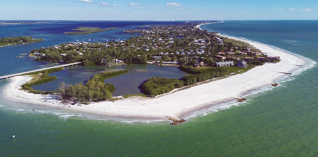
That’s the name of the game with beach erosion, and the trend continued with this year’s “Annual State of the Beaches Update.”
At the Nov. 6 Town Commission meeting, Public Works Program Manager and Assistant Director Charlie Mopps provided commissioners with the latest updates, alongside the town’s coastal engineering consultant Albert Browder with Olsen Associates, Inc.
The firm and town completed the two-year physical monitoring survey right before Hurricane Idalia swept through Florida. This is a good thing, the duo said, because it gives them recent “before” data with which to compare the aftermath of Idalia’s surge.
Longboat Key’s consistent goal is to maintain 120 feet of beach surface from the baseline to shoreline.
The first update Mopps and Browder provided was an overview of the Greer Island Spit Management project. About 20,000 cubic yards of sand was dredged from Greer Island and moved to the north end groin field. The $1.1 million project also included some dune planting and additional signage.
Full damage assessments from Idalia are still ongoing, but Mopps said there was some significant overtopping and erosion of the upper beach berm in the north end. But, there was minimal damage to the dunes.
This was the common theme found along the entire island.
“One of the things that we were definitely impacted by was the deflation of the beach elevation, pretty much islandwide,” Browder said.
But a little further past Greer Island, the north end groins have held up well since they were installed in 2021.
Though Idalia’s surge may have deflated the beach and eroded some berm elevation, beach width has remained steady with the groins.
“This is two years, and after a storm and everything, this is how well this feature has held up,” Mopps said. “So it’s a success story.”
Continuing down the beach, the next area is the area of greatest concern: Gulfside Road.
This area, Browder said, has the worst erosion on the island.
“It remains a problem, it remains a challenge,” he said.
According to the presentation, the area was “highly eroded” before Idalia, and left “severely impacted” after.


Excessive erosion rates have continued, and Browder said he’s been running through multiple scenarios to address the issue. Beach nourishment may be too expensive in the long run, due to how frequently it would need to occur.
One possible solution could be to add shoreline stabilization like groins, rocks and other structures along the shoreline. But any solution like that would need to be carefully planned due to hard bottom and reef structures just offshore, according to Browder.
“But I believe there may be some scenarios where we can provide some modest structural stabilization that will allow for lateral access most of the time around the outside of the Ohana wall,” Browder said.
District 4 Commissioner Debra Williams raised the question of if the problem would still exist if the Ohana Estate seawall were not there.
The Gulfside Road area has historically been more susceptible to higher erosion rates, Browder said, and some form of mitigation would still be necessary if the seawall were to hypothetically disappear.
“It’s not something that the structures themselves are directly causing, but they are certainly making the problem worse,” Browder said.
From Gulfside Road to Bayport Way, the shoreline has remained generally stable. Here, Browder said not a lot of dune retreat was found.
“It’s mostly just an on the beach deflation, which we see mostly on every part of the island,” Browder said.
He also added that some parts of the island were left with burnt dune vegetation. When saltwater washes over dunes, it can impact vegetation. Too much saltwater leaves vegetation in a burnt-like state.
The area from Buttonwood to the Islander Club, there’s a focus on the 1-mile Islander Club area. Again, there was some beach deflation but also some gains in the last year.
There, the shoreline stabilization projects have done their part.
“It has done really well in lowering the erosion rate,” Browder said.
From Hurricane Idalia, the main impact was an islandwide beach deflation due to the surge.
Idalia’s storm surge reached 5 to 5.5 feet above the mean sea level, which is high enough to impact the dunes.
This caused the overwash, but there wasn’t a whole lot of breach, according to Browder and Mopps.
Overwash is when the waves crash over the beach and pull some of the sand back into the ocean, leading to the deflated look. Breach is when the water in the gulf meets the bay, creating an indentation in the sand.
The summary of the physical monitoring completed before Idalia estimated a sand volume loss of 323,600 cubic yards.
The annual regular loss average was also higher than 2006-2022. From October 2021 to August 2023, the annual average was a loss of 176,500 cubic yards. From 2006 to 2022, the annual average loss was 125,700 cubic yards.
Areas of increased loss this year tended to be Gulfside Road, north of the northernmost groin and the south shoreline near New Pass.
But the town’s next project is aimed at mitigating the erosion near New Pass.

The New Pass Terminal Groin tightening project is set to begin this month and last until January 2024. This work will tighten the groin and add rocks to limit the amount of sand passing through the structure.
Browder said he will work with Mopps and the team on tentative plan development for possible scenarios to mitigate erosion at Gulfside Road. But, any plans would need to go through what Browder described as a “rigorous” approval and analysis from the Florida Department of Environmental Protection.
Mopps is also in the process of pursuing grants through FEMA to respond to some of Idalia’s impacts on Longboat’s beaches.


