- June 16, 2026

-
-
Loading
Loading
To continue on the subject du jour, when we recently spoke about the region’s traffic challenges with Adrian Moore, a transportation policy expert at the Reason Foundation and a resident of Siesta Key, he was definitive on the way to solve the backups extending from the Ringling Bridge to Longboat Key: “Sorry,” Moore said, “you have to build another bridge.”
Ah, yes, the Longboat bridge idea. It’s not new. It has been around since the 1960s. Check out what the late Ralph Hunter, founder of the Longboat Observer, chronicled in his 2002 history of Longboat Key, “From Calusas to Condominiums.”
Hunter, an advocate for a bridge to Longboat Key, probably would make the same conclusion today that he did when he wrote this entry in his book:
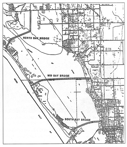
Cross-Bay Bridge
Longboat Key commissioners and residents as early as the late 1960s felt there should be a fixed, toll bridge across the Sarasota Bay linking Longboat Key to the mainland. In 1969, the commissioners authorized the Longboat Key Bridge Committee, which prepared a documented study saying that such a bridge was “urgently needed and feasible.” At the time the population of longboat Key was close to 3,500 residents, many of them seasonal. The study languished at the county level.
In 1973, another study was authorized, and representatives were named from the Florida Department of Transportation, Sarasota and Manatee counties, Longboat Key and the cities of Bradenton and Sarasota. After more than a year, the final report was issued naming 14 possible locations for the bridge. The recommendation was for a fixed bridge to be built near the center of Longboat Key to a place on the mainland.
The plan ran into objections from Longboat commissioners, economists and environmentalists, who thanked everyone for his work and ignored the study.
In 1978, the Metropolitan Planning Organization (MPO) recommended a mainland bridge to Longboat Key and a fixed bridge replacement for the New Pass Bridge in its long-range planning.
After lengthy and acrimonious debate in Longboat Key, Lido Shores and the city of Sarasota, two hold-out Longboat Key commissioners, Sam Seegel and Sid Ochs, agreed to a bascule bridge for New Pass, provided the cross-Bay bridge was put on a fast track. The bascule bridge was built, but the mainland bridge idea died.
In 1980, the Sarasota-Manatee Area Transportation Study (SMATS), which replaced the MPO, did a financial analysis of the cross-Bay bridge question and declared that tolls would not be enough to pay for the bridge.
In March 1981, a Town referendum was held on Longboat Key to vote on whether the residents were in favor of a fixed, cross-Bay bridge. Surprisingly, the vote was yes: 1,505, and no: 440. The favored location was mid-Key.
In 1985, Commissioner Ochs suggested the alternate location for a cross-Bay bridge from Bradenton Beach on the south end of Anna Maria Island to an extension of 53rd Street in Manatee, the direct route to I-75.
Opponents claim a cross-Bay bridge would cost too much, would be ecologically destructive and would necessitate making Gulf of Mexico Drive a four-lane highway. Proponents claim the savings in human life in case of a hurricane makes the idea mandatory, that the bridge would let people off the Key as well as let them on. They claim that it would actually reduce traffic on the Key, since many would go directly to the mainland for shopping and the airport rather than drive over the draw bridges at either end of the Key.
Every few years the idea comes up again. The need for a bridge is apparent to all, but the objectors have won out over the years. Perhaps someday a bridge to the mainland will be a reality, but the odds are against it any time soon.
Here’s where new bridges should go: An offshoot of the east end of the Ringling Bridge to City Island. Make it a toll bridge that bypasses St. Armands Circle. And the North Bay Bridge depicted in the map.


