
- July 6, 2026

-
-
Loading
Loading
Manatee County Commissioner Kevin Van Ostenbridge told a story at the county’s April 15 land use meeting to add some perspective to a land amendment that would allow development beyond the county’s Future Development Area Boundary line under limited circumstances.
“The camel puts his nose under the tent,” Van Ostenbridge said. “And then the camel gets his head under the tent if you don't do anything about it. Next thing you know, the camel is in the tent. … If this property is allowed east of the line, then the camel’s nose is under the tent, right? And then how much further is it going to continue to go?”
Van Ostenbridge’s tale was not a rebuke of development’s eastern push in Manatee County. Rather, it was an acknowledgement that the county’s next decision regarding the development boundary line, which will come in the next six months, will have far-reaching consequences for the future of population growth within the county.
The Manatee County Commission voted 4-3 to transmit the amendment April 15, which means it will be submitted to the Florida Department of Economic Opportunity for review and comments. Commissioners Vanessa Baugh, George Kruse and James Satcher dissented.
Transmitting the amendment, which was submitted by LWR Communities, does not mean it was approved. The Commission will hold a final vote on the amendment within 180 days of transmitting it.
“My vote to transmit is not a vote to approve,” Van Ostenbridge said, a sentiment that was echoed by Commissioner Misty Servia.
Commissioners said they will use the next six months to hold at least one, if not multiple workshops about the development boundary line and how it fits within the larger view of Manatee County population growth. Baugh said to attorney Caleb Grimes, who represented LWR Communities, she wished the development company had met with citizens prior to presenting the amendment before commissioners even though it wasn’t required.
“This is huge for the citizens of Manatee County,” Baugh said. “In essence, we are moving the urban service boundary. Unfortunately, what has come into play — and I totally get it, and I agree — is that you have people that moved east to get away from development. And it's just encroaching and getting closer and closer.”
Commissioner Reggie Bellamy suggested holding a workshop halfway between Bradenton and Myakka City to make it easier for Myakka City residents to attend, an idea with which other commissioners agreed. Although the 15 to 25 residents who showed up April 15 hoped commissioners wouldn’t transmit, they will get another opportunity to make their voices heard.
“Let's stop, pause and involve the people,” Myakka City resident Carol Felts said. “I think if you guys talk to us, we're not unrealistic. And we'd like to work even with the developers to have a better plan for Myakka, because we're not giving up Myakka.”
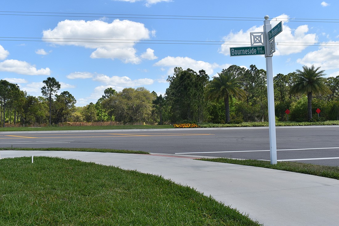
Among the topics of conversation could be the difference between moving the development boundary line and the amendment, which would allow future applications for development on land adjacent and contiguous to the boundary line. In East County, the line is located at Bourneside Boulevard from University Parkway north to State Road 64. It veers slightly westward north of S.R. 64 until it reaches the county’s northern border.
Baugh and Kruse said the amendment would, in effect, amount to moving the line.
“We're taking these things in bits and pieces, as opposed to looking at Manatee County as a whole,” Kruse said. “It should be one big picture, not one little piece at a time based on convenience of who shows up first trying to get a text amendment on each individual thing.”
However, he said one of the negative aspects of the amendment, as opposed to simply moving the line, is it limits who can develop east of the line to only those who own property that touches the line. South of S.R. 64, for example, all property that touches the line is owned by Schroeder-Manatee Ranch.
Kruse said he was also concerned a developer could theoretically buy continuous land to the east and lump it in as part of the same development that bordered the boundary line, thus creating a possible loophole for unlimited sprawl. Grimes said he did not believe the amendment would allow for it, but he added LWR Communities would be open to language that restricted such a possibility.
On the other hand, moving the boundary line would force Manatee County to extend and pay for infrastructure stretching to the line’s new location. Under the proposed amendment, Grimes said developers and new community districts would pay for the infrastructure, which would be connected to roads and utilities already provided by the county. Servia said this is part of the reason she views the amendment as smart growth.
“This is not urban sprawl,” Servia said. “This is the opposite. This is a highly planned community where you're just allowing it to extend at no risk to Manatee County residents, because we don't have to fund the infrastructure. I would like to see a community plan done for Myakka to preserve that area, to make sure their rural flavor stays in place, that the development doesn't creep in on them, so that they can have the community that they want to have.”
The Future Development Area Boundary line was established in 1989 and moved a handful of times over the years before it reached its current location in 2006. It is designed to limit urban sprawl and preserve agriculture as the primary land use east of the line through 2040, according to the county’s Comprehensive Plan.
All new development of more than 0.2 dwelling units per gross acre east of the line is prohibited, with the exception of small commercial development supporting the agricultural community, limited development associated with mining operations, farm worker housing, residences in Myakka City, cluster development to protect open space or agricultural operations and plan amendments resulting from a change in the county’s Future Land Use Concept Map.


