- July 10, 2026

-
-
Loading
Loading
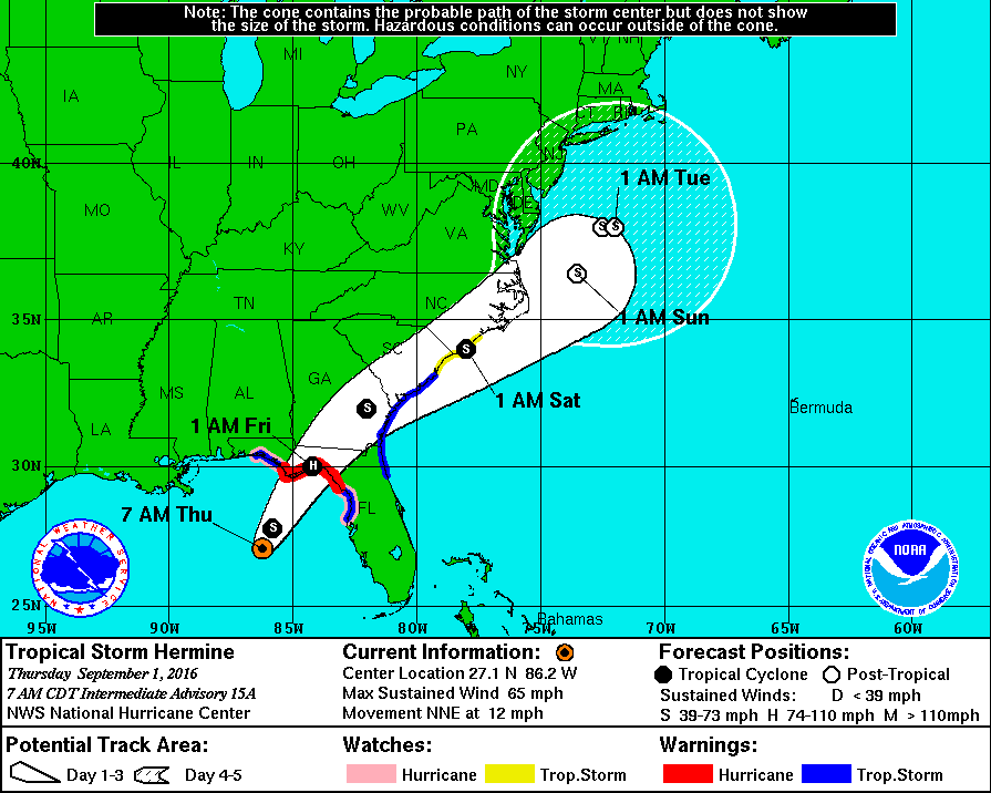
Tropical Storm Hermine is now picking up
speed as it heads toward a Florida Gulf Coast landfall overnight Thursday night, potentially as the state's first hurricane landfall since Hurricane Wilma in 2005, according to the Weather Channel.
Tropical Storm Hermine was centered about 195 miles south-southwest of Apalachicola on Thursday morning.
The biggest threat to the Longboat Key coastline is erosion and flooding, according to the National Weather Service, especially if storm drains or retention ponds overflow.
Sections of near-shore roadways may become weakened or washed out, according to NWS. Major beach erosion is possible with heavy surf breaching dunes. Numerous strong rip currents are expected, too.
Hurricane warnings continue for a swath of north Florida, extending inland to include Tallahassee. This means hurricane-force winds (at least 74 mph) are expected for a period of time in the warned area.
Fortunately, Hermine will now accelerate to the northeast. Faster forward motion will mitigate the heavy rain threat somewhat.
National Weather Service
Fortunately, Hermine will now accelerate to the northeast. Faster forward motion will mitigate the heavy rain threat somewhat.
However, this system will have a deep fetch of tropical moisture along its eastern and southern flanks. Therefore, bands of heavy rain could train along and south of its path over the Florida peninsula possibly into Friday.
The northeast Gulf of Mexico coast from Apalachee Bay to north of St. Petersburg is prone to storm surge flooding thanks to the West Florida Shelf, where the sea floor rises significantly, allowing water driven by a tropical cyclone's winds to pile up.
New tropical storm warnings were issued Thursday morning along the Southeast coast from Florida’s First Coast to a swath of coastal South Carolina, including Jacksonville Beach, St. Simons Island, Hilton Head Island and Charleston. Tropical storm watches were also issued to include Myrtle Beach, South Carolina, Wrightsville Beach and Surf City, N.C.
According to Weather Underground’s Dr. Jeff Masters, this is the first hurricane warning issued for any part of Florida since Hurricane Isaac four years ago.
Hermine finally earned its name Wednesday afternoon after data collected by the NOAA Hurricane Hunters indicated that the system was producing tropical storm-force winds. In addition, satellite imagery showed a better organized system than we've seen in recent days, with wind shear relaxing some.
Infrared satellite imagery, scatterometer data and observations from the Hurricane Hunters continues to show Hermine is a lopsided system, with the strongest winds and thunderstorms in the eastern semicircle of the circulation. As the NHC forecast path shows, Hermine will continue accelerating northeast on a path toward the Florida Gulf Coast.
After its Gulf landfall, the storm will track through southeast Georgia and over or near the Lowcountry of South Carolina and eastern North Carolina to bring rain and wind there Friday and Saturday.
The combination of heavy rainfall and storm surge around the time of the system's landfall Thursday night or early Friday could combine to produce life-threatening flooding along parts of Florida's Gulf Coast.
Potential peak water rise forecasts from the NHC if it occurs at high tide:


