- April 25, 2024

-
-
Loading
Loading
Longboat Key senior planner Maika Arnold estimated she’s worked on the town’s new online zoning map since March.
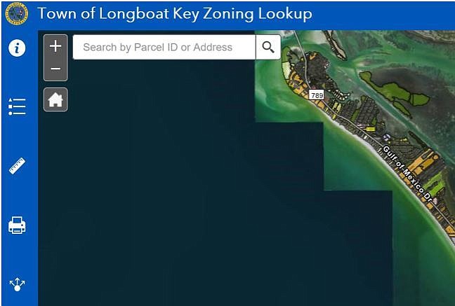
The free online tool made its debut this month.
“We get calls all the time from Realtors and property owners wanting to know what their property is zoned,” Arnold said. “It just made sense to get our zoning online, so it’s a tool for the public to use where they can easily access this information, rather than having to call and sometimes waiting for someone to call them back just to get some simple information.”

Longboat Key’s mapping tool allows users to look up a property either with a parcel ID or address. It shows what the property is zoned and its future-land use. The map also links to the zoning district information and the county’s property appraiser’s website.
Arnold said the new map also will help the town staff.
“It’s something we’ll have to research from time to time; what a property is zoned, what you can do with the properties,” Arnold said. “That’s determined by its zoning district."
Specifically, the town’s mapping tool uses the geographic information system software Esri, whose ArcGIS tool provides thorough context for mapping and spatial reasoning. It allows viewers to explore data and share location-based insights.
Arnold said the map won’t require too much upkeep because the town does not make too many zoning changes.
The most recent example was the December 2019 decision to rezone Grant’s Gardens at 524 Gulf Bay Road. Before Grant’s Gardens, the last rezoning application the town received was in 2015 at the Shore restaurant on Longboat Key, which replaced the former Moore’s Stone Crab Restaurant at 800 Broadway Street.
Arnold said she’s worked from home since the coronavirus pandemic began, which allowed her to spend more time developing the new online map. She worked with an Esri developer to develop and create an application on the company’s online platform to actually build the map.
“It’s really common for cities and counties to have an online GIS platform, and the town didn’t have one,” Arnold said.
The cities of Bradenton and Sarasota offer similar mapping tools.
“It’s really just a tool to help the public know more about their property,” Arnold said. “I just wanted to create something that would be helpful to the public.
Editor's Note: This story has been updated to correct that in 2015 the Shore restaurant submitted a zoning application to the town of Longboat Key, not Mar Vista Dockside Restaurant and Pub.