
- July 4, 2026

-
-
Loading
Loading
Patrick and Amy Heckethorn are avid boaters.
They own a 37-foot Grady White and a 62-foot Viking sport fisherman. One of the reasons they moved to Longboat Key was its boating benefits.
“We have been boaters our whole lives,” said Patrick, a native of Dyersburg, Tenn., which sits along the Mississippi River.
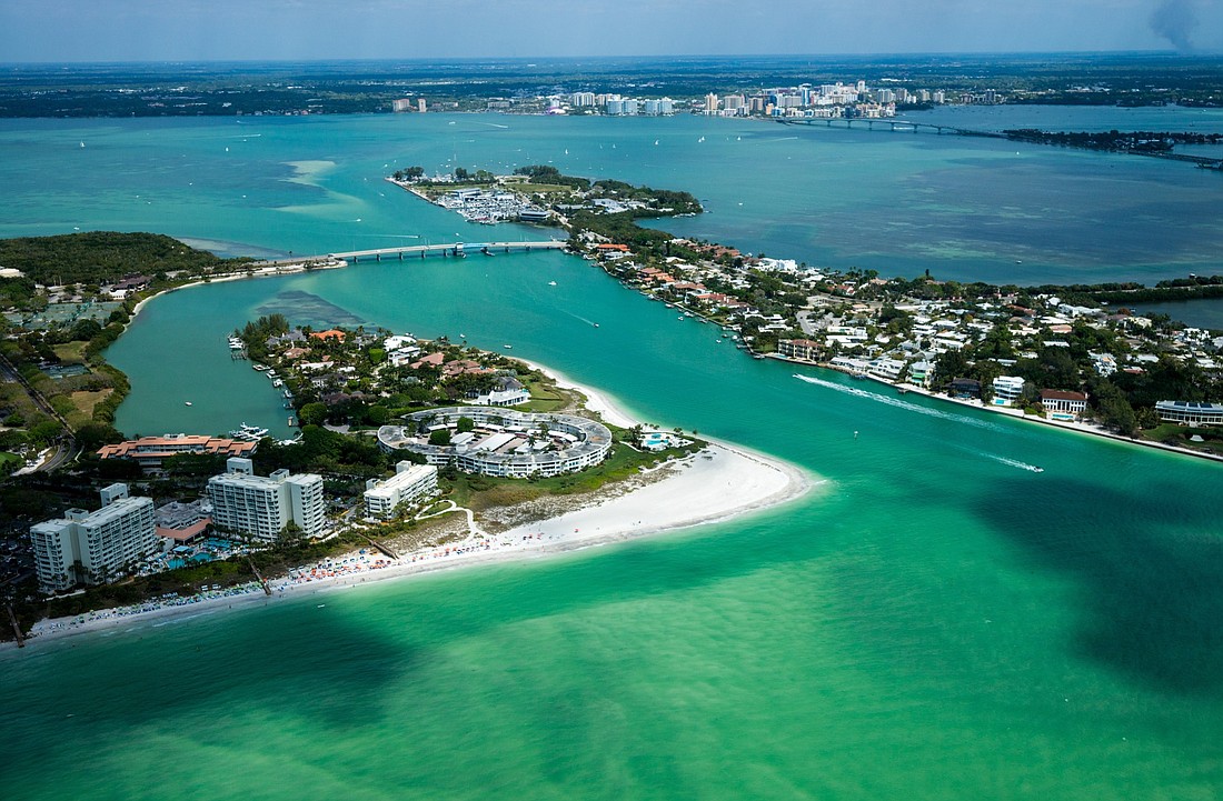
And like many boat owners in town, they have become frustrated about the conditions around New Pass, which connects the Gulf of Mexico and Sarasota Bay at Longboat Key's southern tip. Shoaling conditions made the channel hard to navigate and prompted the U.S. Coast Guard in May 2017 to remove the navigation markers, a signal to boaters that the channel wasn't up to safety standards.
Two channel lights were be converted into “Danger Shoal” markers with quick, white flashing lights, to be visible for three nautical miles.
“We want people to go in a different direction,” explained Michael DeNyse, a U.S. Coast Guard spokesman, meaning Longboat Pass to the north or Big Pass to the south were preferred options.
But now, boaters in the area have something to look forward to.
Before the end of the year, the city of Sarasota has plans to launch a $3.9 million project to remove about 185,000 cubic yards (the equivalent of about 15,000 dump truck loads) from New Pass as an emergency renourishment project for nearby Lido Key.
Alex DavisShaw, Sarasota's city engineer, said Lido Key lost an estimated 15 feet of shoreline in 2017's Hurricane Irma and 2018's first storm, subtropical storm Alberto.
“We need the (New Pass) sand on Lido,” said DavisShaw, making clear the project's goal is renourishment, not navigational improvements for the area's boating community..
Longboat Key and Sarasota have traditionally taken turns dredging New Pass and putting the sand to use in renourishment projects. The last time New Pass was dredged was in late 2016 by Longboat, which sent the sand to the town's south end beaches. Tropical storm Hermine's passage in September of that year hastened the shoaling of New Pass.
The New Pass dredging and placement of sand on Lido Beach should take around 90 days to complete.
The Coast Guard is taking a wait-and-see attitude about whether it will replace the navigation markers in New Pass until the city's project, DeNyse said.
The town of Longboat has a joint permit with Sarasota from the Florida Department of Environmental Protection for the dredging of New Pass, Public Works Director Isaac Brownman said.
“Once (Sarasota) has completed their dredge, it will be 'our turn,' so to speak,” Brownman said. “The dredging would likely be timed with our next major beach re-nourishment.”
Longboat recently placed 30,000 tons of sand, trucked in from a Polk County mine, on a 600-foot stretch of beach on its north end, where beach erosion remains troublesome. Sand-saving groins are also on the drawing board for the same stretch of beach.
Longboat’s next beach re-nourishment project is scheduled for 2021. The town has been re-nourishing its beaches since 1993 and has had more than 3.3 million cubic yards of sand placed along the island’s 9.3-mile shoreline.
Brownman said before the town would dredge New Pass, the channel needs to fill back in so there is enough sand for a beach re-nourishment project.
It is still not known how Hurricane Michael affected New Pass, conditions, Brownman said. When Hurricane Irma swept up the peninsula last year, a net 137,000 cubic yards of sand was gained on the Longboat shoreline, though some spots lost sand and others gained.
Gulf passes are often tricky for boaters, with shifting sands rendering charts or even marked channels unreliable. They can also foster controversy, like the Sarasota's plan to dredge more than a million cubic yards from Big Pass to renourish south Lido. Residents of Siesta Key have objected and sued, claiming not enough is known about the project's effects on their world-famous beach.
Even without markers, plenty of boaters head through New Pass daily. Patrick Heckethorn said he uses his experience and a GPS-based app called GPS Breadcrumbs.
Chris Sileo, another longtime Longboat boater, also relies on his knowledge when going through New Pass on his 35-foot boat.
“But the markers provided me some comfort,” said Sileo, adding the depth of New Pass can vary anywhere from one foot to 20 feet. “It varies from spot to spot.”
“You have to be careful and understand the water,” said Sileo adding that New Pass boating conditions could scare off potential Longboat Key visitors.
Patrick Heckethorn said he has scraped the sandy bottom in New Pass in his Viking, which draws about 5 feet of water.
“New Pass conditions get worse each year,” he said. “It’s almost unnavigable.”
He keeps one of his boats at the Longboat Key Club Moorings and his larger boat at the Twin Dolphin Marina in Bradenton. Because of New Pass, he is thinking about keeping both boats in Bradenton.
“We need passes we can depend on,” he said.


