
- July 1, 2026

-
-
Loading
Loading
City staff is envisioning a future in which Ringling Boulevard serves as a bike-friendly multimodal corridor linking Legacy Trail to downtown Sarasota, with more than 1,000 cyclists a day using the street’s protected lanes.
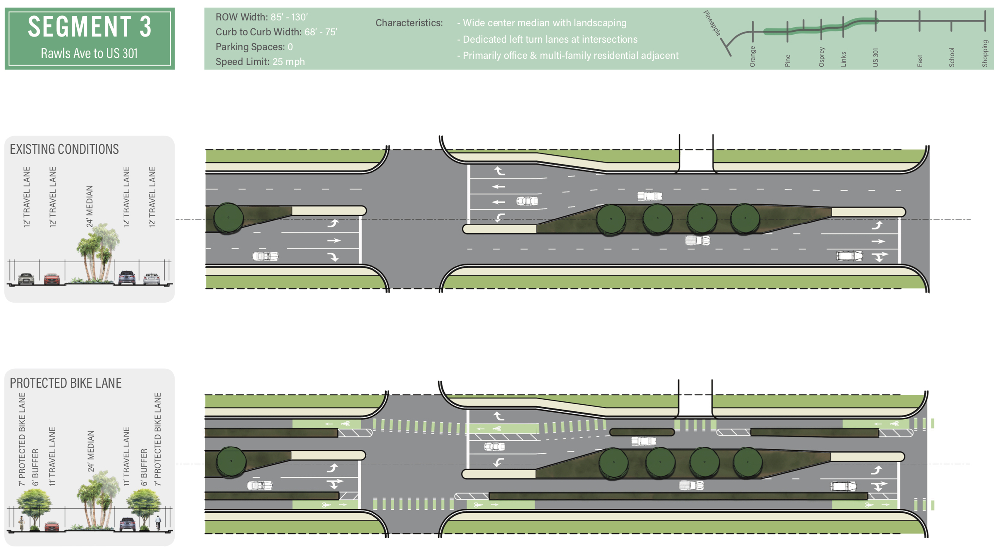
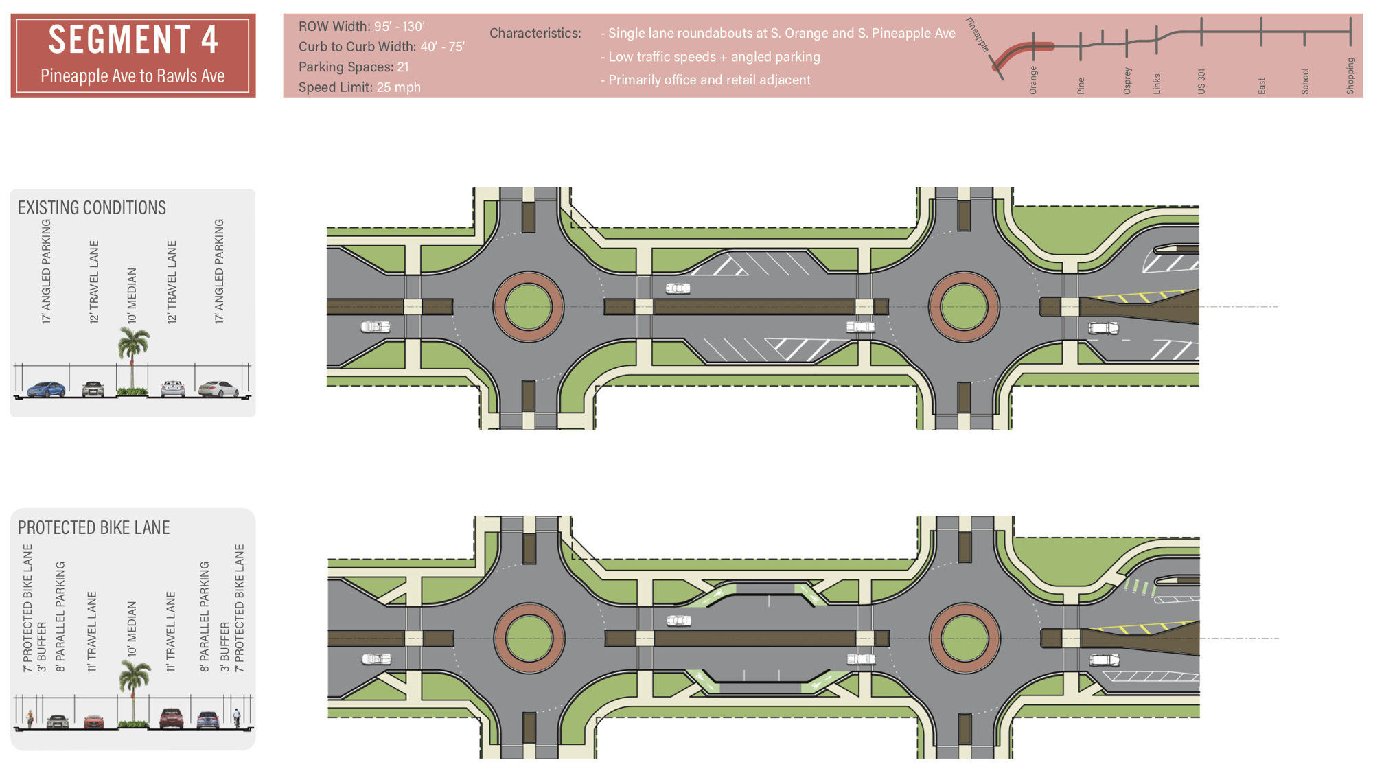
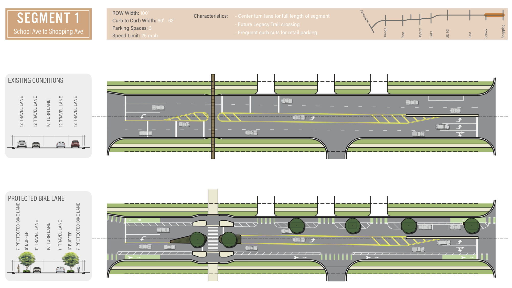
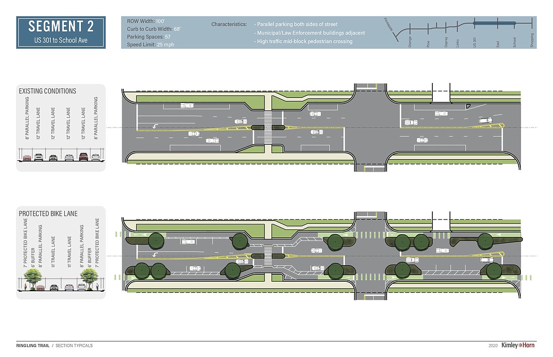
It’s a long road from vision to reality, though. Today, the stretch of Ringling Boulevard between Lime Avenue and Rawls Avenue is at least four lanes wide throughout with no dedicated bike infrastructure. City officials have developed a concept that would transform that stretch into one lane of vehicular travel in each direction, repurposing some space for separated bike lanes and landscaping buffers.
Before bringing that concept to the City Commission for discussion, staff is first seeking public feedback. In October, City Manager Tom Barwin shared plans for the project — called the Ringling Trail — in his weekly email newsletter. The city’s website features detailed information about the proposal, which runs in total from Lime Avenue to Pineapple Avenue, and a link to a survey about what staff has devised so far.
Assistant City Engineer Daniel Ohrenstein said the project is designed to accomplish a series of goals. Last year, the City Commission designated Ringling Boulevard as a future “complete street,” designed to accommodate motorists, pedestrians and cyclists. Officials have expressed an interest in transforming Ringling Boulevard into a route for cyclists, in particular, because it’s the closest major east-west road to the planned Legacy Trail extension in Payne Park.
Ohrenstein believes that, in addition to making the street safer and more convenient for cyclists, the city can help downtown stores and restaurants by bringing Legacy Trail users into the central business district.
“Looking at case studies from around the country, when you do a bike lane project, it does a number of good things for the economy,” Ohrenstein said.
Although city staff has said surveys show broad public interest in improved cycling options, one aspect of the plan has previously proven controversial at the commission level: reducing travel lanes. In 2019, the commission rejected staff’s recommendation to implement a “road diet” on Fruitville Road even after officials shared data that said redesigning the street from four lanes to two lanes would not have reduced the vehicular capacity.
The City Commission has also been concerned about the prospect of overemphasizing multimodal transportation. In July, the commission declined to adopt Sarasota in Motion, staff’s transportation master plan. Although Planning Director Steve Cover said staff accounted for cars while developing the proposal, commissioners felt there was an inadequate focus on motor vehicles.
“This is a recreation, pedestrian and bicycle plan,” City Commissioner Hagen Brody said in July. “This is not a transportation master plan.”
As the city engages the public about the Ringling Trail plan, Ohrenstein is optimistic residents will be OK with losing two travel lanes. That’s partially because Ringling Boulevard has some key distinctions from Fruitville Road. It’s not a state road or the primary east-west link from the interstate to the barrier islands.
“It’s very much a local street,” Ohrenstein said. “Almost all of the traffic going onto [this segment of] Ringling doesn’t come from farther than 2 miles away.”
Before designing its preliminary proposal, the city conducted a traffic study to get more information on the volume of cars using Ringling Boulevard. Fruitville might be a hub for congestion during peak hours and peak season, but Ringling is relatively lightly traveled. The number of cars on the road has declined since 2002, going from as much as 14,000 trips per day to an average of about 7,900 daily trips in 2019.
Even if the vehicular activity on the road goes up, Ohrenstein said staff is confident the two-lane configuration would be adequate.
“What the traffic study found is, even if you assume traffic growth and take that out for the next 20 years, automobile traffic will still flow acceptably well on Ringling Boulevard,” he said.
Based on the feedback the city has received so far, Ohrenstein thinks much of the public shares staff’s vision for the street. Out of 304 responses, more than 75% of participants said they either dislike or strongly dislike the current layout of Ringling Boulevard. At least 80% of respondents said they strongly liked a design option that would incorporate protected bike lanes and one vehicular travel lane in each direction, as is the case for staff’s proposal.
The concept earned a unanimous endorsement from the board of the Downtown Improvement District, a group of property owners in the downtown core.
“It’s a pretty popular idea,” Ohrenstein said.
After the online survey closes Nov. 15, Ohrenstein said staff intends to bring the concept to the City Commission for consideration and additional direction. Even if the board supports the concept, Ohrenstein said there would be more opportunities for public input before a design and plan is finalized.
The possibility of construction is still a ways away, but staff is hopeful that it’s developed the basis for a project that will ultimately transform Ringling Boulevard for the better.
“We’ve got a great deal of extra capacity,” Ohrenstein said. “We’ve got the Legacy Trail coming into downtown now. How do we get the most of that for downtown businesses and downtown residents?”


