- July 25, 2026

-
-
Loading
Loading
Higher seawalls, built-up roads, knee-high walls along Gulf of Mexico Drive and complex drainage systems are among a town consultant’s ideas to head off sea-level rise on Longboat Key over the next three to five decades, according to notions delivered in a draft report to town leaders this month.
Town staff have been working with consultants from Aptim Environmental & Infrastructure Inc. since 2018 to assess the town’s infrastructure in a four-phase study designed to prepare the island into the 2070s. Nearing the end of the third phase, Aptim presented draft recommendations to the Town Commission on June 20 with plans to submit a final phase-three report in the fall.
From there, funding and priorities can be worked on and timelines laid out for the work ahead. Aptim’s initial estimates for private and public projects reach as high as $50 million (in current dollars) by 2040.
"We do see there are a substantial number of homes in the town that were developed in the 1960s and the 1970s before the town adopted modern flood-control measures through your ordinances, so there are a number of homes in town that are below the base flood elevation today and are at risk," said Doug Mann, lead coastal engineer with Aptim.
Mann said that by 2070, abnormally high tides, referred to as king tides, could affect about 450 town structures, based on current projections and building-elevation data gathered by Aptim, but that figure falls away further into the future, based on the numbers of structures built to modern-day elevation standards.
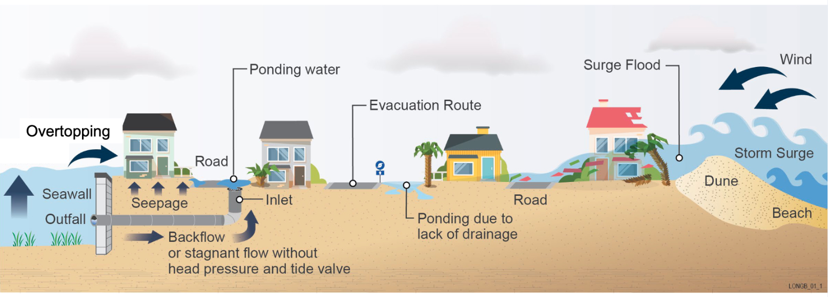
Aptim data also shows about 2 miles of the town’s approximately 200 miles of seawalls — mostly private — will be overtopped by 2040.
Mann added that projection is conservative but also subject to change as actual levels are monitored and potential effects recalculated over three or four decades. "We’ll see how things progress as we move forward," he said.
The town has already made some progress toward making the island more resilient, including installing one-way valves on stormwater infrastructure to ease street flooding during high tides, enacting a ordinance to allow higher seawalls, rebuilding a street to head off frequent flooding and adding a truck to its Fire-Rescue fleet for high-water rescues.
The town’s work with Aptim is designed to create a comprehensive plan with a list of projects and improvements to protect the town from rising seas.
Bob Bunting, the CEO of Sarasota’s Climate Adaptation Center, said in a hurricane-preparation seminar this month that sea levels have risen 9 inches since 1950. In a report this year by the National Oceanic and Atmospheric Administration, sea levels along United States coastlines are predicted to rise as much as 1 foot by 2050, with the east coast and Gulf coast expected to see the fastest rise because of settling soils combined with rising waters.
Explaining the split between public and private responsibility, Samantha Danchuk of Aptim said government’s role would be largely focused on regulatory policy, land-use decisions, protection of public assets and maintaining a desired level of service for roads and stormwater-drainage and storage systems.
Private property owners would be responsible for backyard seawalls, flood-proofing or elevating homes and businesses, and keeping sea level in mind when designing and building new businesses, housing developments, condos or streets.
Together, the public and private sectors would need to work together on land-use options for the future, designating sites for stormwater retention and other facets.
"There is this nexus between those where there are opportunities to think about how can we really solve the problem together," she said.
Danchuk said that as the town moves ahead, projects designed to protect against more severe storm effects, such as surge from the Gulf of Mexico and Sarasota Bay, can also serve as longer-term solutions for the more-gradual rise of sea levels.
Among those first concerns are projects to restore beachfront dunes in about 10 locations to form a first line of defense against a stormy sea. Also, plans to raise vulnerable electrical systems at town sewer-pumping stations could serve to insulate them not only from immediate storm threats but for decades to come as well.
"If you start to address storm surge now and think about ways to become resilient to storm surge, you essentially are building in the protection for sea-level rise," she said, adding funding for storm-surge protection is available from several sources. "When we talk about storm surge, we’re talking about several feet. As you start to decide where you want to invest to protect against storm surge, you really are already providing sea-level rise protection."
Danchuk told the Town Commission that such policy-driven decisions as allowing for higher private seawalls are an example of something that could protect against surge now and higher sea levels for decades. Additionally, shifting stormwater regulations from using historical models to projections similar to those used by Aptim would make sense as well.
The challenge, she said, is not only identifying lower and more vulnerable areas of the island but also figuring out ways to keep water from finding low spots in seawalls, roadways or other barriers, adding it’s nearly impossible to actively pump or drain seawater when it pours in.
Using Longbeach Village as a potential example, Danchuk spoke about the potential for one day building up a perimeter road in a design called a "polder" in Holland, which is a thoroughfare built higher than its surroundings as a dike-like feature. She also mentioned low walls along Gulf of Mexico Drive that could serve to keep the island’s main road open, even if rising waters from bayside canals threatened to inundate the roadway from the east
Floodgates at the end of residential canals that could be closed during king tides or storms, land-use designations to allow for water retention along public right of ways or on private lands through incentives.
"I do want to note that flooding will still occur with mitigation during extreme events, so you want to be very careful during the community outreach process, especially if we’re talking about active stormwater management," she said. "There could still be a really, really intense rain storm or a hurricane, and there will be flooding. Sometimes people, when they hear you’re coming in to address flooding, they think their neighborhood will always be dry."


