- April 28, 2024

-
-
Loading
Loading
St. Armands Circle is now open to all traffic. Longboat Key is now accessible via the Ringling Bridge and St. Armands Circle.
Longboat Key residents, business owners and employees will be allowed to use the side streets of St. Armands Key, the town said in an update.
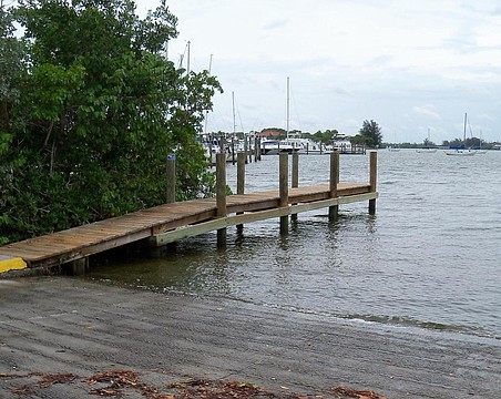
St. Armands Circle remains flooded.
The north Siesta bridge at Siesta Drive is now open, according to Sarasota Police. It is only passable via one lane. SPD requests drivers exercise caution because many of the side streets on Siesta Key are still flooded.
The city of Sarasota announced at approximately 5 p.m. that Ringling Bridge is open to residents and business owners of Lido Key and St. Armands Key. Only residents and business owners will be be allowed to return. Resident and business owners must provide proper documentation. St. Armands Circle remains closed due to flooding.
All School District of Manatee County schools except Anna Maria Elementary School will reopen Thursday. Extracurricular activities and athletics also will resume, but some athletic games and practices might be postponed depending on the availability of the teams involved.
Access to Longboat Key is open to only residents and business owners via Manatee Avenue and Cortez bridges and Longboat Pass Bridge.
The John Ringling Causeway Bridge is now open until Bird Key, according to the Sarasota Police. West of Bird Key, including St. Armands Key and Lido Key, remains closed due to flooding. Northbound and southbound U.S. 41 at the bayfront is now open, including the Gulfstream roundabout. The Siesta Key bridge at Siesta Drive remains closed.
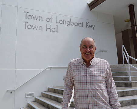
Longboat Key Fire Chief Paul Dezzi reported that the island would remain closed for the time being, dependent on the water receding.
Widespread flooding has made many roads impassable for a standard vehicle, and Dezzi said the island would not be opened until the emergency response team is certain it’s safe for people to drive back onto the island.
Residents should wait for more information available through Alert Longboat Key to stay up to date on reentry protocol.
Public schools in Sarasota County that were serving as emergency evacuation centers have closed and are in the process of being cleaned and reconfigured to welcome back students and employees. All evacuated residents have left the shelters.
Sarasota County Schools will reopen Thursday for normal school operations, including transportation services, food services and after-school activities. Additionally, the Superintendent Listening Tour meeting slated for Thursday evening at Riverview High School will be held as scheduled. If your child is enrolled at a charter school, check directly with the school for updates on reopening.
School buses will be running as normal but might be delayed due to receding water and excess traffic moving through the county. The district uses WheresTheBus, which offers real-time updates. For more information about the app and how to sign up, visit: SarasotaCountySchools.net.
SRQ has recorded 3.12 inches of rain since Tuesday morning.
At 10:55 a.m. Wednesday the Sarasota Fire Department was dispatched to a reported commercial structure fire at 300 John Ringling Boulevard on St. Armands Key. The address is the Tommy Bahama restaurant. Monitoring the radio traffic indicates that white smoke was emerging from underground at the Tommy Bahama store, 371 St Armands Circle. The ground floor was reported as flooded, and once the power was cut to the building the smoke stopped. The emergency response was canceled.
The Sarasota Police Department has released a video showing much of St. Armand’s Circle streets and circle park flooded. The barrier islands remain closed to traffic.
Road closures in Sarasota:
Hurricane Idalia has passed Longboat Key, but storm impacts continue to create dangerous conditions on the island.
The town of Longboat Key encourages anyone still on the island to remain in their homes due to dangerous flooding on roads, downed power lines and other risks. A town communication at 9 a.m. Wednesday included the following information:
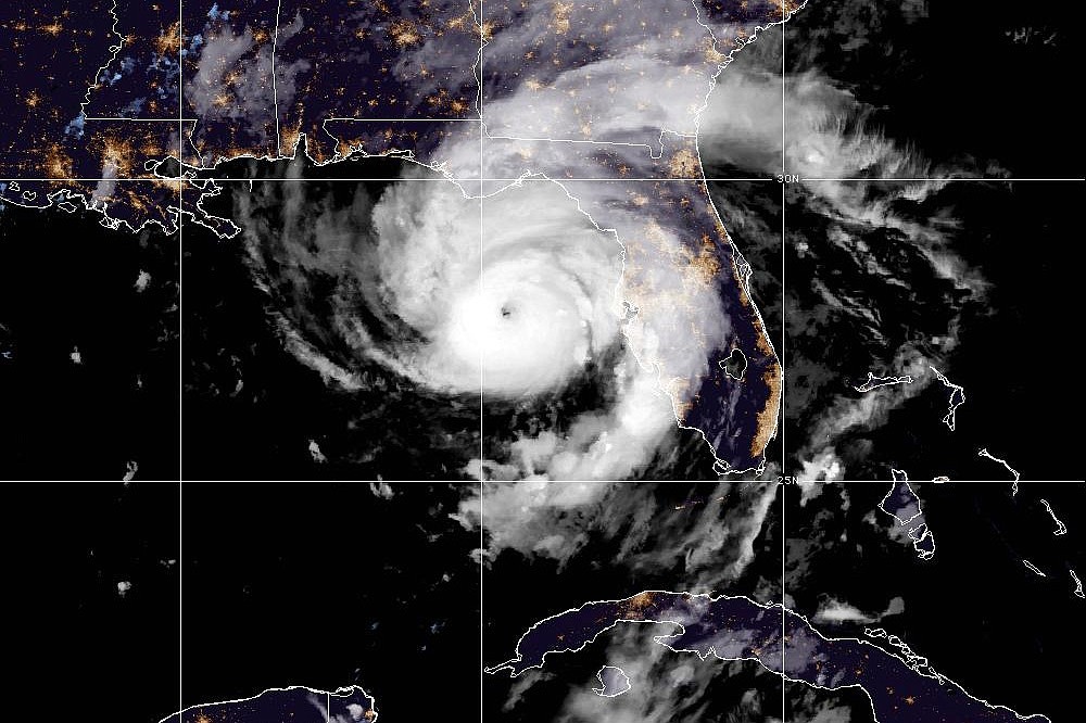
Idalia made landfall at 7:45 a.m. in Florida's Big Bend region as a Category 3 hurricane with 125 mph winds.
Roads along the Sarasota bayfront and in downtown are flooding. The Sarasota Police Department has shut down the following areas and is actively putting up more barricades in other affected areas:

More flooding is expected Wednesday afternoon during high tide. Currently accessible areas may be under water later in the day.

The Sarasota-Bradenton International Airport reopened at 8 a.m. Wednesday.
A majority of the Sarasota bayfront has been closed because of flooding from Hurricane Idalia, including U.S. 41 from Main Street to Fruitville Road. Officials expect the water at the bayfront to recede following high tide, beginning at 12:15 p.m. In addition, several vessels have been damaged or have sunk in the Marina Jack basin.
The north bridge to Siesta Key at Siesta Drive is closed because of flooding. On St. Armands Key, the area of North Washington Drive at John Ringling Boulevard is under several feet of water. Officials are urging residents to not travel to the barrier islands as conditions are expected to worsen through Wednesday.
Idalia has strengthened into a Category 4 hurricane as it nears Florida's Big Bend region. It has maximum sustained winds of 130 mph with tropical-storm-force winds extending 175 miles from the center of the storm.
Manatee County remains under a storm surge warning and a hurricane warning. Sarasota County remains under a storm surge warning and a tropical storm warning.
SRQ measured 32 mph wind with 51 mph gusts at about 5 a.m. Wednesday.
Hurricane Idalia is passing 125 miles west of Tampa Bay with 110 maximum sustained winds. The NOAA forecasts it to be a Category 4 hurricane with 130 mph winds when it makes landfall Wednesday late morning.
At about 11 p.m., the Sarasota-Bradenton International Airport recorded 35 mph wind with gusts of 48 mph. There have been 1.18 inches of precipitation over the past three hours.
Manatee and Sarasota counties are under a tornado watch until 6 a.m. Wednesday.
Hurricane Idalia has maximum sustained winds of 105 mph. Tropical-storm-force winds extend 160 miles from the center of the storm.
Sarasota County Schools has said the reopening of traditional public schools for normal operations will depend upon the track of Hurricane Idalia. The school district said it will need time to clean and prepare schools to receive students and employees and will provide an update on reopening as soon as possible after the storm passes and staff are able to assess the condition of the facilities.
Idalia is now a Category 2 hurricane, with 100 mph winds. The storm is about 195 miles southwest of Tampa and is moving north at 16 mph.
Sarasota County is no longer under a hurricane watch but remains under a storm surge warning and a tropical storm warning.
The center of Hurricane Idalia is forecast to make landfall Wednesday morning in Florida's Big Bend region.

Maximum sustained winds have increased to 90 mph; Idalia will become a Category 2 hurricane when winds reach 96 mph, which is expected later Tuesday.
Tropical-storm-force winds extend 160 miles from the center of Hurricane Idalia.
Manatee County remains under a storm surge warning and a hurricane warning. Sarasota County remains under a storm surge warning, a tropical storm warning and a hurricane watch.
The Sarasota-Bradenton International Airport will close to all air traffic and the terminal will be locked and secured beginning at 7 p.m. Tuesday. The airport plans to reopen Wednesday, pending damage assessment. Travelers should check with their airlines for the latest flight information.
The airport terminal is not a shelter. Updates will be posted on the SRQ Facebook page and on X (Twitter).
Sarasota County Public Works staff are locking down local moveable bridges over the Intracoastal Waterway. They should be considered closed to marine traffic and open to vehicular traffic.
Affected county bridges are Manasota Beach Road, Venice Avenue, Albee Road and Blackburn Point Road.
The Florida Department of Transportation is also locking its bridges in Sarasota County including Circus Bridge on south U.S. 41 in Venice, Hatchett Creek Bridge on north U.S. 41 in Venice, Stickney Point Road, Siesta Drive and New Pass.
All of the bridges should be considered closed to marine traffic and open to vehicular traffic.
Hurricane Idalia has strengthened, now with 85 mph maximum sustained winds. It is moving north at 14 mph. The storm is expected to move faster north through early Wednesday.
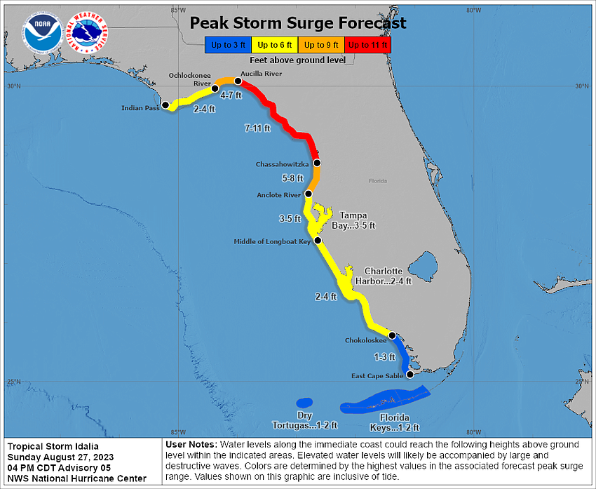
Storm surge is forecast to be 4-7 feet in Manatee County and 3-5 feet in Sarasota County. Peak wind count be 45-60 mph in the Tampa Bay region. Tornadoes are possible.
The earliest reasonable arrival time of tropical-storm-force winds to the Sarasota-Manatee region is Tuesday evening; winds are most likely to arrive Tuesday night.
Hurricane Idalia is forecast to make landfall around 10 a.m. Wednesday in the Big Bend region with 125 mph winds.
All of Longboat Key is under an order to evacuate as both Sarasota and Manatee counties have issued evacuation orders for Zone A, with Manatee issuing a mandatory evacuation order.
Zone A encompasses the entirety of Longboat Key.
Recent forecasts project Hurricane Idalia to make landfall as a Category 3 storm near Cedar Key, Florida, on Wednesday around 10 a.m.
Despite the current forecast, the town of Longboat Key shared the following information for residents to use in their their decision-making:
The town of Longboat Key offices will remain closed on Tuesday. The town is evaluating conditions to determine office hours on Wednesday. Updates will be posted to the town’s website LongboatKey.org, Facebook, Twitter and Instagram if conditions change.

Although Hurricane Idalia is now expected to skirt past the Manatee County coast, public officials continue to warn residents that the path of the storm could change in a heartbeat.
“It’s important to remember how unpredictable these storms can be,” said Manatee County Public Safety Deputy Director Steve Litschauer in a release. “We need to stay vigilant as the conditions continue to deteriorate.”
Wind and rain will be a factor, Litschauer said, but the primary concern continues to be storm surge — with the worst of the weather anticipated to impact Manatee County late Tuesday into early Wednesday.
The release stated: "Everyone in Level A evacuation areas—and those living in mobile or manufactured homes or RVs—in Manatee County must evacuate in advance of this storm. There is a voluntary evacuation in effect for those living in Level B. You can find your evacuation level at MyManatee.org/ManateeReady."
MyManatee.org/sandbags lists where citizens can pick up sandbags if needed.
At 2 p.m. Tuesday, Manatee County Area Transit buses will suspend operations until further notice, the release said.
Sarasota County is calling for the evacuation of Level A. It is not a mandatory evacuation at this time. Evacuations centers are now open.
In addition, the county will be shutting off water service to residents and businesses on Casey Key starting at 3 p.m. Tuesday, Aug. 29. The county will wait until after the storm to restore water service.

Maximum sustained winds have increased to 75 mph, making Idalia a Category 1 hurricane. The storm is moving north at 14 mph.
The center of Hurricane Idalia is forecast to move through the eastern Gulf of Mexico on Tuesday and make landfall in Florida on Wednesday.
Tropical Storm Idalia is lingering near Cuba with 70 mph maximum sustained winds, the NOAA reports.
There is no change to watches or warnings.
The earliest reasonable arrival time of tropical-storm-force winds to the Sarasota-Manatee region is Tuesday afternoon; winds are most likely to arrive around 8 p.m. Tuesday. A rainfall total of 4-8 inches is possible.

Idalia remains with 70 mph maximum sustained winds, nearing a hurricane. Rapid strengthening is forecast over the next day, and Idalia is expected to become a major hurricane by Tuesday night.
Tropical-storm-force winds extend 150 miles from the center.
A storm surge of 4-7 feet is expected in Manatee County and of 3-5 feet in Sarasota.

Tropical Storm Idalia is nearing hurricane strength, the NOAA states. A hurricane warning remains in effect for Manatee County, and a tropical storm warning and a hurricane watch remain for Sarasota County.
There is a danger of life-threatening storm surge inundation along the coast, including in Sarasota and Manatee counties.
Tropical-storm-force winds are expected to reach the Sarasota-Manatee region Tuesday evening.
Idalia is forecast to have maximum winds of 120 mph in 36 hours, which would make it a Category 3 hurricane.
Solid waste collection for unincorporated Sarasota County is canceled for for Tuesday. Collections are scheduled to return on Wednesday, but garbage, recycling and yard waste collection services will be delayed by one day for the remainder of the week.
Garbage, recycling and yard waste collection in the city of Sarasota is suspended Tuesday.
Manatee County has moved its evacuations to mandatory in Level A and voluntary in Level B. Find your evacuation level using the county's Learn Your Level map tool.

Tropical Storm Idalia nears western Cuba with maximum sustained winds of 70 mph and higher gusts. Tropical-storm-force winds extend 140 miles from the center.
Hurricane conditions are expected to hit the region late Tuesday or Wednesday.
Coastal Manatee County is forecast to get 4-7 feet of storm surge. Sarasota County is forecast to get 3-5 feet.
All School District of Manatee County schools will be closed Tuesday and Wednesday.
All extracurricular activities and athletic events will end as of 6 p.m. Monday.
Freedom Elementary School will serve as a shelter open to the public while R. Dan Nolan Middle School will be a shelter open for individuals with special needs.
More schools could open as shelters based on need.
Sarasota County issued an evacuation order for Level A scheduled to take effect Tuesday, according to an emergency brief update. This includes vessels, RVs and mobile homes.
Find your evacuation level using the county's Know Your Level map tool.
The city of Sarasota has issued a state of emergency.
Sarasota County will open evacuation centers at 8 a.m. Tuesday. No evacuations have yet been ordered.
Sandbag operations are scheduled to from 2-7 p.m. Monday and from 7 a.m. to noon Tuesday at the following locations:
Sandbags are limited to 10 per vehicle. Shovels and bags will be available on site. For more information visit SCGov.net/BePrepared.
Sarasota County Schools announced, "Traditional public schools will be closed on Tuesday, August 29 and Wednesday, August 30 in order to function as Evacuation Centers."
Evacuation centers will open at 8 a.m. Tuesday, Aug. 29. A list of current evacuation centers can be found at Sarasota County’s website.
For students enrolled in charter schools, check directly with the school for updates on closures.
All after-school activities Monday, Aug. 28 will take place as scheduled.

Maximum sustained winds remain at 65 mph as Tropical Storm Idalia approaches western Cuba.
The region is under a storm surge warning. Mid-Longboat Key and north is under a hurricane warning; mid-Longboat and south is under a tropical storm warning and hurricane watch.
Idalia is moving north at 8 mph and expected to move faster north-northeast Tuesday and Wednesday. Tropical-storm-force winds extend 105 miles from the center. It is forecast to be a Category 3 hurricane early Wednesday.
Manatee County has issues a state of emergency.

Tropical Storm Idalia is forecast to strengthen into a major hurricane before reaching Florida.
Hurricane-force winds could reach the coast by Tuesday evening. The region remains in a hurricane watch and a storm surge watch.
Idalia has maximum sustained winds of 65 mph and is moving at 7 mph. Tropical-storm-force winds extend 70 miles from the center of the storm. It is expected to pass near or over Cuba on Monday and then increase in speed before hitting Florida on Wednesday. The NOAA forecasts it to become a hurricane on Monday and a dangerous major hurricane by early Wednesday.

By the time it reaches the southeastern Gulf of Mexico, Tropical Storm Idalia is forecast to strengthen into a hurricane.
The storm has been moving "erratically" and has already strengthened more than anticipated, the NOAA says. Maximum sustained winds have reached 60 mph.
Peak storm surge estimations have increased to 4-7 feet in Manatee County and 3-5 feet in Sarasota County.
The Sarasota-Manatee region is under a storm surge watch and a hurricane watch. "A watch is typically issued 48 hours before the anticipated first occurrence of tropical-storm-force winds, conditions that make outside preparations difficult or dangerous," the NOAA states.
If peak surge happens at high tide, water could rise 3-5 feet from mid-Longboat Key north to Anclote River and could rise 2-4 feet from mid-Longboat Key south to Chokoloskee. Three to 6 inches of rainfall is expected on Florida's west coast from Tuesday into Wednesday.
Sarasota County coastal waters are also under a special marine warning through 6 p.m. Sunday.
Tropical Storm Idalia is moving northeast at 3 mph and is forecast to strengthen into a Category 2 hurricane Wednesday.

Tropical Depression 10 has strengthened into Tropical Storm Idalia. Maximum sustained winds are at 40 mph.

The late-summer awakening in the tropics has brought the threat of a hurricane to the Gulf Coast. Gov. Ron DeSantis has declared a state of emergency for several counties, including Sarasota and Manatee, to prepare for a potential landfall of a tropical system moving across the Yucatán Peninsula of Mexico on Sunday morning.
Tropical Depression 10 is forecast to become a tropical storm Sunday and to strengthen during the next few days and become a hurricane over the eastern Gulf of Mexico with the potential of storm surge, heavy rains and strong winds to portions of the West Coast of the state by mid-week. Tropical-storm-force winds are currently estimated to reach the region on Tuesday.
Sarasota County’s Emergency Operations Center encourages residents to review their emergency preparedness plans.
Visit the Sarasota County website at SCGov.net/BePrepared and for preparedness information visit the city’s website at AlertCitySarasota.com.