- April 27, 2024

-
-
Loading
Loading
MANATEE COUNTY — With results of the 2011 census in, Manatee County officials are well on their way to setting new district boundaries for the Manatee County Board of County Commissioners.
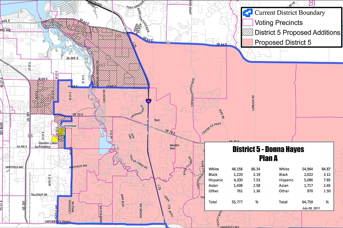
District 5, which includes the majority of the East County, actually will be expanding slightly westward and increasing in population under all three proposed scenarios.
Deputy County Administrator Karen Windon said the change, comes in part, because redistricting maps finalized in 2005 were designed to accommodate significant growth in the East County — much of which was not realized once the housing market started to collapse. The district, represented by Commissioner Donna Hayes, currently includes about 13,000 people less than Manatee’s other districts.
Its boundaries run to the county’s eastern border from Interstate 75 and include the entire area between State Road 64 and State Road 70. Heading west of the interstate, the district spans west roughly to Lockwood Ridge Road and north to 44th Avenue. Several communities west of Lockwood Ridge fall within the district’s boundaries, as well.
“Most of Lockwood Ridge, we’ve tried to square off as much as possible,” Windon said of the new boundary configurations.
Because Manatee County is seeing an increase in building permits for the District 5 area, one proposal — Plan C — has been created to accommodate future growth in the district, while evening out existing numbers, Windon said.
“With Plan C, you get a little more difference in the population,” Windon said, noting the county is trying to keep all districts within a population block of 2,000 people.
The county began reviewing U.S. census data in May, at which time Manatee County Geographic Information Systems staff used the census data to produce a first draft of maps. County staff then worked to balance populations while maintaining the existing geographic balance in each district. Boundaries drawn were based on existing districts and changed based on geographic lines.
Manatee County commissioners also added input as part of the process.
“They know their districts and they know their neighborhoods that are being cut in half by those lines,” Windon said.
The Manatee County Supervisor of Elections has reviewed the proposed districts, as well, to ensure precinct boundaries were protected from change.
County officials hosted a public meeting Sept. 27 to solicit input on the proposed boundaries.
By law, Manatee County must finalize its new district boundaries by the end of December, but county officials hope to complete the task in October or early November, Windon said.
Contact Pam Eubanks at [email protected].
Click on the player below to view redistricting plans A, B and C.