- April 24, 2024

-
-
Loading
Loading
EAST COUNTY — The Fort Hamer Bridge is coming.
The U.S. Coast Guard issued the last permit needed to move forward on the project June 27, marking the end of a permitting process that took four years to complete.
The estimated $22 million two-lane north-south bridge will now enter the design phase, said Ken Bontrager, bridge project manager for Manatee County.
“This is a pretty big milestone for the project,” Bontrager said. “This means the permitting process is finally complete.”
Bontrager anticipates design will be finished by September.
Bids for construction would soon follow and construction likely will begin in February 2015.
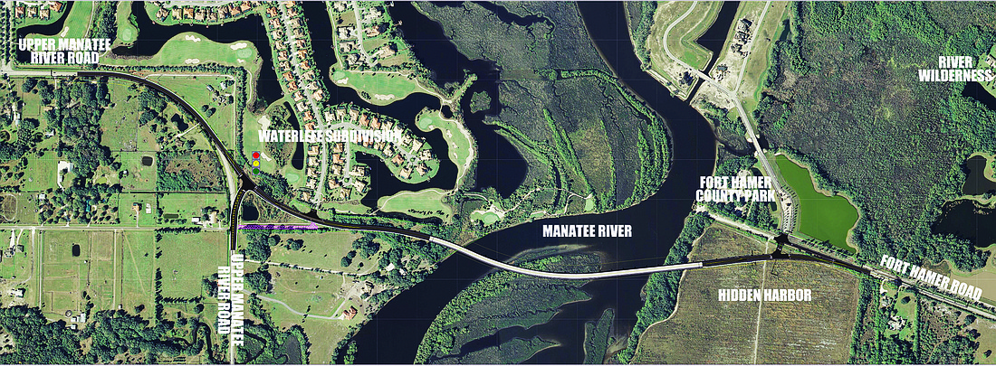
Once finished, the bridge will connect Fort Hamer Park to Upper Manatee River Road.
The road to complete permit approval was multifold.
Because the bridge crosses over a body of water, it must receive permitting from the U.S. Coast Guard.
To persuade the Coast Guard to OK the bridge, the project had to meet requirements spelled out in the National Environmental Policy Act (NEPA), said Marty Peate, senior project manager for URS Corp., the company hired to oversee completion of the environmental impact study for the bridge project.
Peate helped conduct the review process to ensure the bridge complies with
NEPA requirements.
More than 30 factors are considered throughout the process of deciding if a project meets NEPA standards, including environmental impacts, alternative routes and economical factors.
NEPA also factors in other requirements, such as satisfying clean air, endangered species, historic preservation and other acts already in place.
“The NEPA process is a discovery and disclosure process for decision making,” Peate said. “You evaluate the conditions of the area of where you want to build something before you take any action. You want to make sure you minimize the impacts; you just want to be cost effective and construct something that satisfies the main reason for doing the project.”
Throughout the NEPA evaluation, Peate and URS considered a range of scenarios to determine whether other alternatives would benefit the surrounding roadways, such as Rye Road.
Upper Manatee River Road will connect the proposed bridge to State Road 64 and Rye Road.
In the analysis, URS considered widening the Rye Road Bridge to cross over Manatee River. Peate thought the idea would help ease congestion on I-75 for local drivers.
“You only really have Rye Road there, unless you use the interstate,” Peate said. “Local drivers are just trying to get across that river. All those local trips taken by people who never intended to use the interstate will now have the opportunity for local trips on local roads.”
But in its final report, URS found the Fort Hamer Bridge option provided shorter emergency-response times and proved more cost effective than expanding the Rye Road Bridge — a best-case scenario.
The project, formerly known as the Manatee River Road Brige project, has been in the works since since 1999, then as a Florida Department of Transportation project. It lost steam around 2005, Peate said.
Manatee County decided to resurrect the project around 2009.
Today, Bontrager thinks of the bigger picture in what the bridge represents — a fast and safe route during emergencies.
“Fort Hamer will allow people north of the river to come to the south to receive medical attention, and the bridge will be another hurricane evacuation route if I-75 gets too full or closes down,” Bontrager said.
“People will have an alternate way to cross the river.”
+ Bridge basics
Once finished, the Fort Hamer Bridge will cross the Manatee River to connect Upper Manatee River Road to the south with Fort Hamer Road to the north.
The two-lane bridge will be about 2,200 linear feet and will include 10-foot shoulder/auxiliary lanes on each side of the travel lanes. It also will have a 5-foot sidewalk on one side of the bridge.
Manatee County considers the bridget the final piece in the long-planned 44th Avenue Extension, which connects Cortez Road and its nearby beaches in the west to Lakewood Ranch and the surrounding area, in the east.
The U.S. Coast Guard held its last public meeting on the project in August 2013. The organization endorsed the Fort Hamer proposal over other options, in April.
Contact Amanda Sebastiano at [email protected].