- April 18, 2024

-
-
Loading
Loading

New flood insurance rate maps released by the Federal Emergency Management Agency may offer financial relief to some homeowners in the Heritage Harbour and Waterlefe Golf and River Club communities.
According to the newly proposed FEMA maps, dozens of homes south of the Manatee River, north of Port Harbour Parkway and west of Upper Manatee River Road may no longer require flood insurance because of changes in base flood elevations. The base flood elevation is the elevation at which floodwater is expected to rise during a flood event.
Flood insurance is required for homesites below or at up to 4 feet above base flood elevation. The proposed FEMA maps affect hundreds of houses.
Preliminary FEMA maps show about 100 properties along roads like Grand Estuary Trail, River Hammock Drive, Windingbrook Lane, Riverbank Terrace and Winding Stream Way have been removed from high-risk zones and no longer require flood insurance.
“If you meet base flood elevation, for every foot above that, the rates go down,” said Manatee County Floodplain Section Manager Sandy Tudor.
In flood zones, flood insurance rates are based on how high or low a property sits compared with the base flood elevation.
Tudor said even a 1-foot increase in elevation can translate into savings for homeowners.
In Florida, annual flood insurance prices start around $400 and can exceed $5,000. Costs are based on factors like your flood risk level (flood zone), your property’s elevation and the value of the home. FEMA insures up to $250,000.
Flood elevation certificates, surveys verifying property elevations, are required for insurance rate changes.
Tudor said each property owner should check his home and lot to see if he is impacted by the proposed changes. In some cases, the lot may be in a high-risk flood area, while the home itself is not. In that situation, no flood insurance is required.
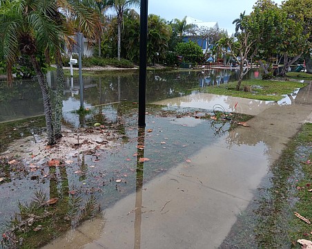
Manatee County’s Stormwater Engineering Division Manager Thomas Gerstenberger said freshwater flooding along the Manatee River typically only occurs during heavy rain events in which water is released from the Lake Manatee Dam. Although the dam releases water to control water levels at Lake Manatee, the flooding it may cause typically occurs once every five to 10 years.
The biggest change for the maps, however, is related to storm surge. FEMA now predicts storm surge along the Manatee River from I-75 east to Upper Manatee River Road, an area previously not considered at risk for storm surge from
coastal flooding.
For Heritage Harbour residents in River Strand and Stoneybrook, that generally means homes previously in flood areas for the Manatee River instead now may be subject to coastal flooding from storm surges.
“It’s a different flooding scenario than it would have been in the past,” Gerstenberger said. “Now, the Manatee River is impacted by storm surge.”
Gerstenberger said although homeowners in the area may no longer need flood insurance or have changes in their rates, even those without flood insurance should be prepared for natural disasters.
“There is no such thing as a no-risk flood zone in Manatee County,” Gerstenberger said.
Federal Emergency Management Agency Region IV spokesman Danon Lucas said FEMA soon will accept comments and appeals from property owners about the changes, but the timeframe for that period has not yet been determined. A 90-day appeal period will be advertised in local media. After that, any issues will be resolved and there will be a six-month adoption period before the new maps become effective.
LEARN MORE
To learn more about the Federal Emergency Management Agency’s proposed flood rate insurance maps and to see how your property may be impacted, visit mymanatee.org. Visitors can find the “Building and Development Services” tab and then click “Find My Flood Zone.”
You can also visit msc.fema.gov/fmcv to view proposed changes.