- April 20, 2024

-
-
Loading
Loading
Colorado State University researchers predicted an active hurricane season this year, but one storm nearly broke the record for the latest-forming first hurricane in the Atlantic Ocean.
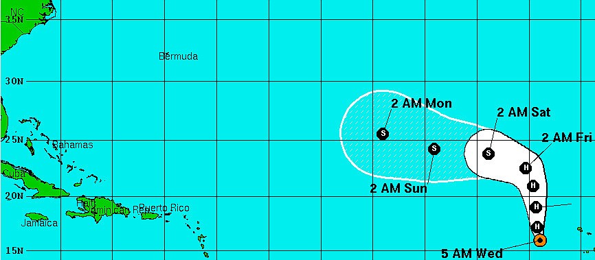
Hurricane Humberto formed early Wednesday, Sept. 11, becoming the first hurricane to take shape in the Atlantic Ocean this seas, according to the National Weather Service. The storm currently has maximim sustained winds of 75 miles per hour, and is tracking toward the U.S. at 8 miles per hour.
Hurricane Humberto is expected to weaken to a tropical storm by early Saturday, according to forecasts.
Click here to learn how Sarasota County officials stay vigilant for tropical cyclones and other disasters.
Earlier: Tropical Storm Gabrielle formed and fizzled last week, but a new tropical cyclone in the Atlantic Ocean has taken shape.
Tropical Storm Humberto, which has maximum wind speeds of roughly 40 miles per hour, is tracking west toward the U.S., according to an 8 a.m. update from the National Weather Service. The storm, which is less than 4,000 miles away from the coast of Florida, is slated to become a hurricane by 2 a.m. Wednesday, Sept. 11.
The NWS is also monitoring the remnants of Tropical Storm Gabrielle, which has a 20% probability of becoming a tropical cyclone. That elongated band of low pressure is located about 500 miles south of Bermuda.