- April 18, 2024

-
-
Loading
Loading
Longboat Key officials are warning residents that a low-pressure system pushing across the Southeast United States today will bring numerous showers and thunderstorms to the island Wednesday afternoon. The storms are expected to continue through the weekend.
The peak time for hazardous weather anticipated for Longboat Key will be Wednesday evening through Thursday afternoon.
The most severe weather associated with this system, however, will be felt in the Tampa region and northward.
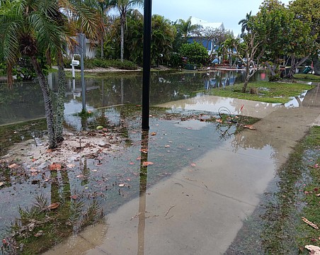
When traveling, residents should be aware of the potential for street flooding and flooding in low-lying areas. The higher-than-normal tides associated with a full moon will affect flooding conditions in low-lying areas of Longboat Key. The highest tides during this period will occur Wednesday, Dec. 2, at 11 p.m. and Thursday, Dec. 3, at 11:50 p.m.
Residents should monitor local weather stations for current storm and weather updates and be prepared to take appropriate protective measures in the event severe weather conditions develop.
Although the impacts to Longboat Key are anticipated to be less intense, island residents can anticipate hazardous weather in the form of:
• Heavy rainfall Wednesday evening through Friday of 1-3 inches, continuing through the weekend with rainfall totals up to 3-5 inches
• Potential for flooding in low-lying areas
• Higher than normal tides ranging from 1-3 feet
• Onshore winds of more than 25 knots, with gusts up to 35 knots
• More than 7-foot seas near shore
• High surf advisory
• Beach erosion
• Rip currents along the beach
• Small craft advisory in coastal waters
• Potential for tornadoes
Additional information will be posted to the Town’s Web site, www.longboatkey.org, if conditions change.
Contact Kurt Schultheis at [email protected].