- April 19, 2024

-
-
Loading
Loading
A voluntary evacuation of Sarasota County's barrier islands, low-lying mainland areas and mobile homes will likely go into effect at 7 a.m. Friday morning, under current forecast conditions, Sarasota County Emergency Management Chief Ed McCrane said at a Thursday news conference.
County officials have not yet made a decision about opening shelters, but are training staff and volunteers to run them if needed for volunteer evacuees or out-of-area evacuees.
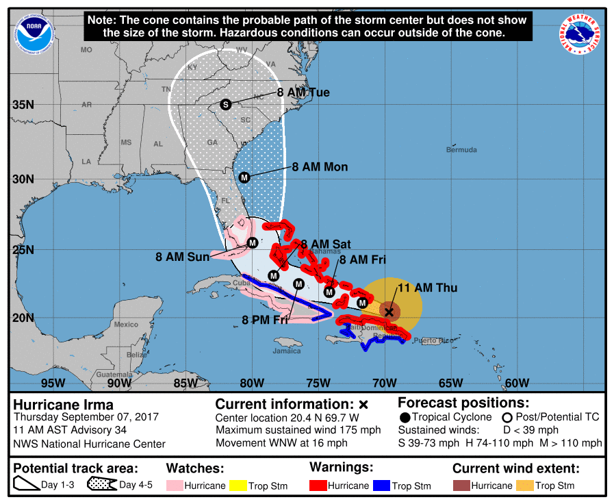
A mandatory evacuation would not be warranted unless the storm changes its predicted track, McCrane said. If the storm does not turn north at Cuba, as expected, or shifts even slightly west, it could bring 9-15 feet of storm surge to the gulf coast. A hurricane watch extends from Bonita Beach around the tip of Florida and through the Keys back up the east coast to Jupiter Inlet. No watches or warnings are in effect for the Sarasota area, but that could change later in the day.
“The difference between three to six hours in that [northern] movement can have significant impacts in the effects that we’ll get,” McCrane said.
Based on the current forecast track up the east coast, however, he expects anywhere from 1-6 feet of storm surge, and only when the storm's center passes north of Sarasota County's latitude.
“As you can imagine, 6 feet of storm surge is problematic,” he said. “It’s not catastrophic, but it’s problematic for all of our beach hotels and homes, and we want to make sure that nobody gets surprised with water in their homes in the middle of the night.”
Despite this, flooding from rain is not a major concern from Hurricane Irma — McCrane expects the heaviest rain to stay to the east of the storm. Perhaps 3.5 inches are expected here.
Predictions on Thursday call for winds of 35-45 mph, initially from the northeast, shifting to the northwest as the storm moves up the east coast. At 45 mph, emergency vehicles will not venture out, so McCrane advised residents to plan and have supplies on hand.
McCrane expects wind to pick up on Sunday, with conditions deteriorating throughout Saturday. That timing could be delayed if the storm slows down.
“We definitely have time on our side,” he said, and county officials continue to monitor the storm.