- April 22, 2024

-
-
Loading
Loading
As St. Armands property owners, residents and merchants waited to meet with representatives from the Florida Department of Transportation the morning of Feb. 4, they speculated on the cause of the officials’ tardiness. Most likely, those in attendance agreed, they were stuck in traffic.
The St. Armands Business Improvement District was meeting with FDOT to discuss those same traffic issues. Attendees painted a grim picture of the situation: During rush hour, traffic backs up all the way around St. Armands Circle, taking 40 minutes to an hour to get to the mainland or Longboat Key. The traffic is an issue on Longboat, too; during peak hours, cars are lined up from the Circle to the Publix on Bay Isles Parkway.
“We’ve got clients coming from all over the world to shop on St. Armands Circle, and they can’t get home, and they get frustrated,” BID board member Michael Valentino said.
At least two things make the this season’s traffic different from past years, according to St. Armands stakeholders. First, traffic is worse than it has ever been, they say — and with new projects planned near the John Ringling Causeway, overcrowding appears poised to get worse.
The second factor, however, is they believe there may be some simple fixes to help mitigate the issues. Those on St. Armands think that, by coordinating a series of lights between the mainland and the Circle more effectively — at Fruitville Road, Gulfstream Avenue, Sunset Drive and Bird Key Drive — the flow of traffic could be improved. The same goes for Longboat Key, they say, if traffic signals at the Longboat Key Club and Ken Thompson Parkway on City Island were more harmonious.
“What happens is you get stopped at one, and then you get stopped again,” said Hugh Fiore, president of the St. Armands Residents Association.
According to city engineer Alex DavisShaw, staff is working with FDOT to better coordinate traffic signals. That work is likely to continue through March and won’t provide much in the way of immediate relief.
L.K. Nandam, FDOT’s District 1 traffic operations engineer, was surprised to hear how bad things had gotten. He agreed to look at whether the timing of the traffic signals was exacerbating traffic and report back to St. Armands stakeholders in a couple of weeks. If the problem could be addressed with existing infrastructure, he said, implementing a solution should be relatively straightforward — and quick.
But Nandam, DavisShaw and St. Armands representatives all agreed that traffic issues wouldn’t be fixed simply by better coordinating lights. A series of roundabouts planned for U.S. 41 should help, Nandam said, but those are still years away. Asked what she thought would mitigate traffic, DavisShaw said:
“My real opinion? The solution to the problem is another bridge.”
Nandam agreed that many of roads are simply being pushed beyond their intended capacities.
But people on St. Armands were eager for a more immediate solution. Residents suggested that, during rush hour, police officers could direct traffic at busy intersections.
Nandam said that, while that is often works for smaller streets, it doesn’t at bigger intersections like the ones at Fruitville and Gulfstream. With so much competing movement, it’s hard for officers to judge how to facilitate the flow of cars.
The group also suggested crossing guards on the Circle to help control pedestrian traffic. But even if stakeholders wanted to implement some of the proposed solutions, it’s unlikely that money would be available.
“We have a couple of ways to try to solve the problem, but no matter what we look at, we say we have no money,” said Diana Corrigan, executive director of the St. Armands Circle Association.
Ultimately, Nandam said, the best solutions would reduce the number of vehicles on the roads.
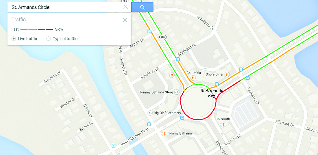
GOOGLE YOUR TRAFFIC
Town Manager Dave Bullock and Assistant Town Manager Anne Ross have been using Google Traffic, an option under the Google Maps cellphone app, to monitor traffic on the Key.
Here’s how it works:
Android phone data is sent to Google, which captures the movement of phones traveling on the roads via algorithms.
From your computer, click on Google Maps, type in an address, hit the “traffic” tab and make sure “live traffic” is checked. Users can then see green lines on the route for flowing traffic, orange lines for moderate traffic and red lines for traffic that’s not moving.
Smartphones require users to download the Google Maps app and follow the same instructions. Phones will show red dots if traffic is moving slowly and green dots if phone data show cars moving at reasonable speeds.
— Kurt Schultheis