- April 25, 2024

-
-
Loading
Loading
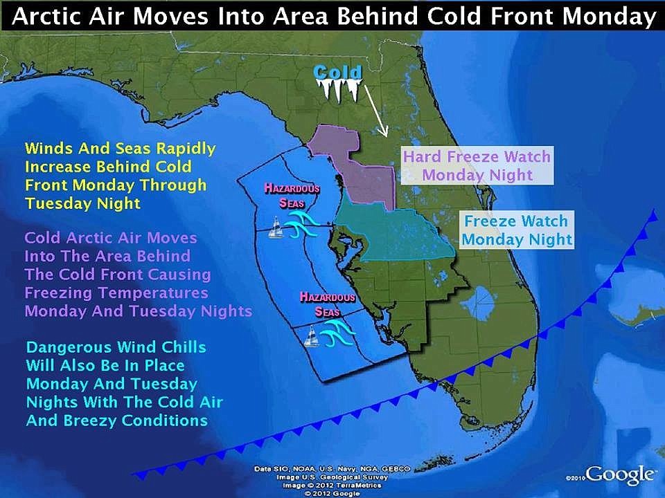
Southwest Florida is about to get a taste of the record-breaking winter storm that has affected most of the country.
Although the area will be spared the arctic cold and blizzards that spread across much of the Midwest over the weekend, Southwest Florida can still expect rough seas, high winds, and temperatures below freezing going into Monday night.
According to Sarasota County Emergency Management, a strong cold front will move across the region Monday followed by much colder drier air for Monday night into Wednesday.
Small Craft Advisories will be needed Monday and Tuesday across the eastern Gulf of Mexico.
Northerly winds will increase to 20 to 30 knots with gusts to gale force behind the cold front sweeping into the area on Monday and Tuesday.
Tides may run a foot or so above normal tonight into early Monday morning in the southwest to west flow ahead of the cold front, but winds will shift to northerly behind the boundary before coastal flooding problems are anticipated.
A Hard Freeze Watch is in effect Monday night into early Tuesday for Levy, Citrus, Inland Hernando and Sumter Counties due to the potential of two or more hours of temperatures at or below 27 F.
Freeze Watch is in effect Monday night into early Tuesday for Coastal Hernando, Pasco, Hillsborough, and Polk Counties for the potential of two or more hours of temperatures at or below 32 F.
A Wind Chill Advisory will be in effect for Sarasota County.
Contact Nolan Peterson at [email protected]